You are here: Home > Network List > TA - USArray Transportable Network (new EarthScope stations) Stations List
> Station R50A Paris, KY, USA > Earthquake Result Viewer
R50A Paris, KY, USA - Earthquake Result Viewer
| Earthquake location: |
East Of Kuril Islands |
| Earthquake latitude/longitude: |
50.0/157.7 |
| Earthquake time(UTC): |
2013/04/19 (109) 19:58:40 GMT |
| Earthquake Depth: |
15 km |
| Earthquake Magnitude: |
6.1 MW, 5.9 MB, 6.0 MW, 6.1 MS |
| Earthquake Catalog/Contributor: |
NEIC PDE/NEIC PDE-W |
|
| Network: |
TA USArray Transportable Network (new EarthScope stations) |
| Station: |
R50A Paris, KY, USA |
| Lat/Lon: |
38.28 N/84.33 W |
| Elevation: |
255 m |
|
| Distance: |
76.6 deg |
| Az: |
45.584 deg |
| Baz: |
324.118 deg |
| Ray Param: |
0.050897934 |
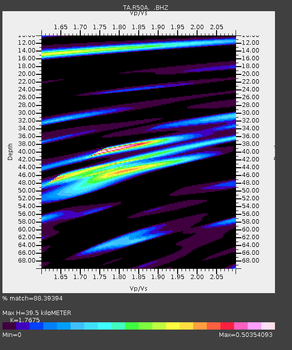
| Estimated Moho Depth: |
39.5 km |
| Estimated Crust Vp/Vs: |
1.77 |
| Assumed Crust Vp: |
6.498 km/s |
| Estimated Crust Vs: |
3.676 km/s |
| Estimated Crust Poisson's Ratio: |
0.26 |
|
| Radial Match: |
88.39394 % |
| Radial Bump: |
369 |
| Transverse Match: |
67.79654 % |
| Transverse Bump: |
400 |
| SOD ConfigId: |
512894 |
| Insert Time: |
2013-09-13 12:59:10.294 +0000 |
| GWidth: |
2.5 |
| Max Bumps: |
400 |
| Tol: |
0.001 |
|
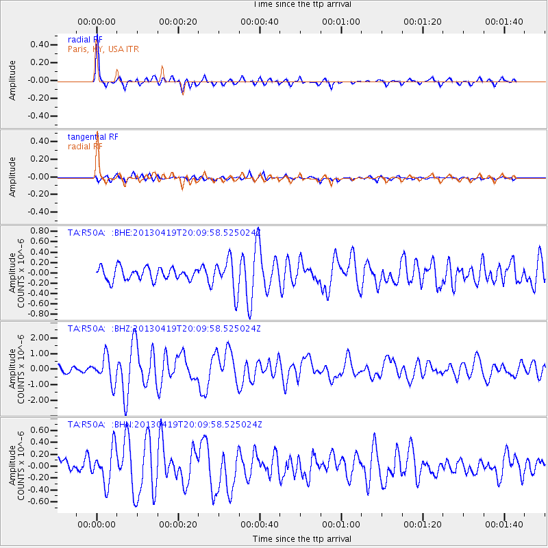
Signal To Noise
| Channel | StoN | STA | LTA |
| TA:R50A: :BHZ:20130419T20:09:58.525024Z | 4.663709 | 8.7930084E-7 | 1.885411E-7 |
| TA:R50A: :BHN:20130419T20:09:58.525024Z | 2.5666573 | 3.122996E-7 | 1.2167561E-7 |
| TA:R50A: :BHE:20130419T20:09:58.525024Z | 2.8212497 | 3.314428E-7 | 1.17480845E-7 |
| Arrivals |
| Ps | 4.8 SECOND |
| PpPs | 16 SECOND |
| PsPs/PpSs | 21 SECOND |


