You are here: Home > Network List > TA - USArray Transportable Network (new EarthScope stations) Stations List
> Station R52A Catlettsburg, KY, USA > Earthquake Result Viewer
R52A Catlettsburg, KY, USA - Earthquake Result Viewer
*The percent match for this event was below the threshold and hence no stack was calculated.
| Earthquake location: |
East Of Kuril Islands |
| Earthquake latitude/longitude: |
50.0/157.7 |
| Earthquake time(UTC): |
2013/04/19 (109) 19:58:40 GMT |
| Earthquake Depth: |
15 km |
| Earthquake Magnitude: |
6.1 MW, 5.9 MB, 6.0 MW, 6.1 MS |
| Earthquake Catalog/Contributor: |
NEIC PDE/NEIC PDE-W |
|
| Network: |
TA USArray Transportable Network (new EarthScope stations) |
| Station: |
R52A Catlettsburg, KY, USA |
| Lat/Lon: |
38.34 N/82.64 W |
| Elevation: |
300 m |
|
| Distance: |
77.3 deg |
| Az: |
44.445 deg |
| Baz: |
324.899 deg |
| Ray Param: |
$rayparam |
*The percent match for this event was below the threshold and hence was not used in the summary stack. |
|
| Radial Match: |
71.85672 % |
| Radial Bump: |
400 |
| Transverse Match: |
61.224483 % |
| Transverse Bump: |
400 |
| SOD ConfigId: |
512894 |
| Insert Time: |
2013-09-13 12:59:18.390 +0000 |
| GWidth: |
2.5 |
| Max Bumps: |
400 |
| Tol: |
0.001 |
|
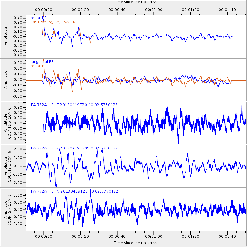
Signal To Noise
| Channel | StoN | STA | LTA |
| TA:R52A: :BHZ:20130419T20:10:02.575012Z | 2.8038688 | 8.719279E-7 | 3.1097315E-7 |
| TA:R52A: :BHN:20130419T20:10:02.575012Z | 1.3261662 | 2.8705793E-7 | 2.1645698E-7 |
| TA:R52A: :BHE:20130419T20:10:02.575012Z | 1.3451247 | 3.8482506E-7 | 2.8608875E-7 |
| Arrivals |
| Ps | |
| PpPs | |
| PsPs/PpSs | |


