You are here: Home > Network List > TA - USArray Transportable Network (new EarthScope stations) Stations List
> Station S49A Springfield, KY, USA > Earthquake Result Viewer
S49A Springfield, KY, USA - Earthquake Result Viewer
| Earthquake location: |
East Of Kuril Islands |
| Earthquake latitude/longitude: |
50.0/157.7 |
| Earthquake time(UTC): |
2013/04/19 (109) 19:58:40 GMT |
| Earthquake Depth: |
15 km |
| Earthquake Magnitude: |
6.1 MW, 5.9 MB, 6.0 MW, 6.1 MS |
| Earthquake Catalog/Contributor: |
NEIC PDE/NEIC PDE-W |
|
| Network: |
TA USArray Transportable Network (new EarthScope stations) |
| Station: |
S49A Springfield, KY, USA |
| Lat/Lon: |
37.78 N/85.29 W |
| Elevation: |
230 m |
|
| Distance: |
76.5 deg |
| Az: |
46.515 deg |
| Baz: |
323.745 deg |
| Ray Param: |
0.05092852 |
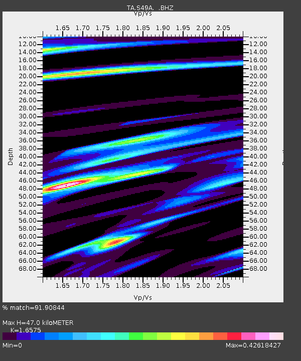
| Estimated Moho Depth: |
47.0 km |
| Estimated Crust Vp/Vs: |
1.66 |
| Assumed Crust Vp: |
6.476 km/s |
| Estimated Crust Vs: |
3.907 km/s |
| Estimated Crust Poisson's Ratio: |
0.21 |
|
| Radial Match: |
91.90844 % |
| Radial Bump: |
259 |
| Transverse Match: |
83.34941 % |
| Transverse Bump: |
345 |
| SOD ConfigId: |
512894 |
| Insert Time: |
2013-09-13 12:59:52.275 +0000 |
| GWidth: |
2.5 |
| Max Bumps: |
400 |
| Tol: |
0.001 |
|
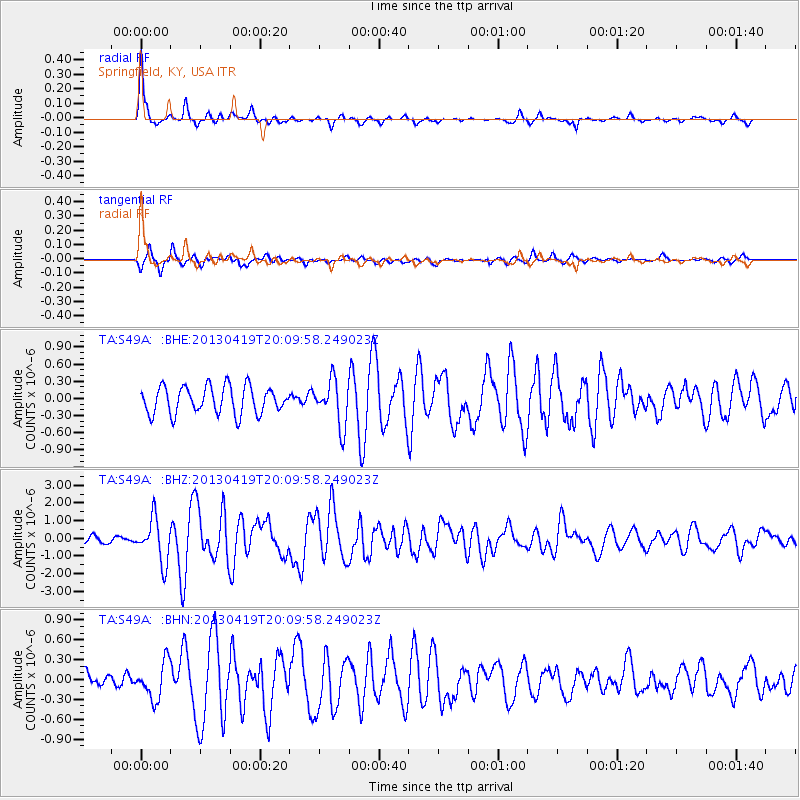
Signal To Noise
| Channel | StoN | STA | LTA |
| TA:S49A: :BHZ:20130419T20:09:58.249023Z | 6.9352045 | 1.217263E-6 | 1.7551942E-7 |
| TA:S49A: :BHN:20130419T20:09:58.249023Z | 2.392576 | 2.7838232E-7 | 1.1635255E-7 |
| TA:S49A: :BHE:20130419T20:09:58.249023Z | 1.6596118 | 3.9366358E-7 | 2.3720219E-7 |
| Arrivals |
| Ps | 4.9 SECOND |
| PpPs | 19 SECOND |
| PsPs/PpSs | 24 SECOND |


