You are here: Home > Network List > TA - USArray Transportable Network (new EarthScope stations) Stations List
> Station S48A Wiedeman Farm, Cecilia, KY, USA > Earthquake Result Viewer
S48A Wiedeman Farm, Cecilia, KY, USA - Earthquake Result Viewer
| Earthquake location: |
East Of Kuril Islands |
| Earthquake latitude/longitude: |
50.0/157.7 |
| Earthquake time(UTC): |
2013/04/19 (109) 19:58:40 GMT |
| Earthquake Depth: |
15 km |
| Earthquake Magnitude: |
6.1 MW, 5.9 MB, 6.0 MW, 6.1 MS |
| Earthquake Catalog/Contributor: |
NEIC PDE/NEIC PDE-W |
|
| Network: |
TA USArray Transportable Network (new EarthScope stations) |
| Station: |
S48A Wiedeman Farm, Cecilia, KY, USA |
| Lat/Lon: |
37.66 N/86.06 W |
| Elevation: |
238 m |
|
| Distance: |
76.3 deg |
| Az: |
47.097 deg |
| Baz: |
323.414 deg |
| Ray Param: |
0.051103014 |
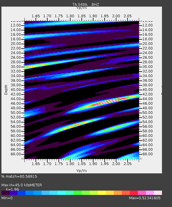
| Estimated Moho Depth: |
45.0 km |
| Estimated Crust Vp/Vs: |
1.96 |
| Assumed Crust Vp: |
6.444 km/s |
| Estimated Crust Vs: |
3.288 km/s |
| Estimated Crust Poisson's Ratio: |
0.32 |
|
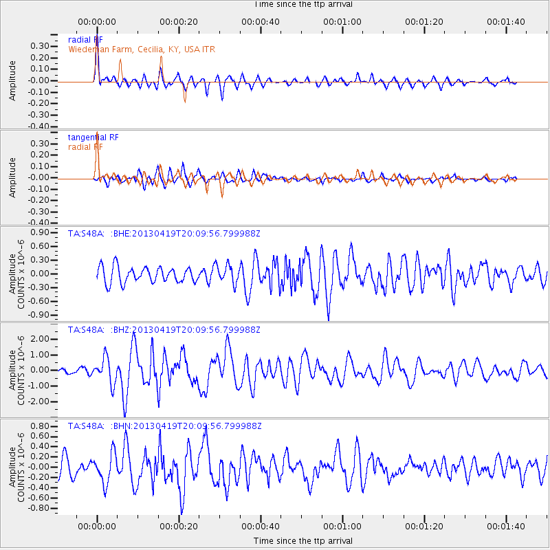
| Radial Match: |
80.56915 % |
| Radial Bump: |
400 |
| Transverse Match: |
73.88047 % |
| Transverse Bump: |
400 |
| SOD ConfigId: |
512894 |
| Insert Time: |
2013-09-13 12:59:52.334 +0000 |
| GWidth: |
2.5 |
| Max Bumps: |
400 |
| Tol: |
0.001 |
|
Signal To Noise
| Channel | StoN | STA | LTA |
| TA:S48A: :BHZ:20130419T20:09:56.799988Z | 5.508045 | 8.323129E-7 | 1.5110858E-7 |
| TA:S48A: :BHN:20130419T20:09:56.799988Z | 2.0882127 | 2.9460213E-7 | 1.410786E-7 |
| TA:S48A: :BHE:20130419T20:09:56.799988Z | 1.1603286 | 1.9712417E-7 | 1.698865E-7 |
| Arrivals |
| Ps | 6.9 SECOND |
| PpPs | 20 SECOND |
| PsPs/PpSs | 27 SECOND |


