You are here: Home > Network List > TA - USArray Transportable Network (new EarthScope stations) Stations List
> Station SFIN Lafayette, IN, USA > Earthquake Result Viewer
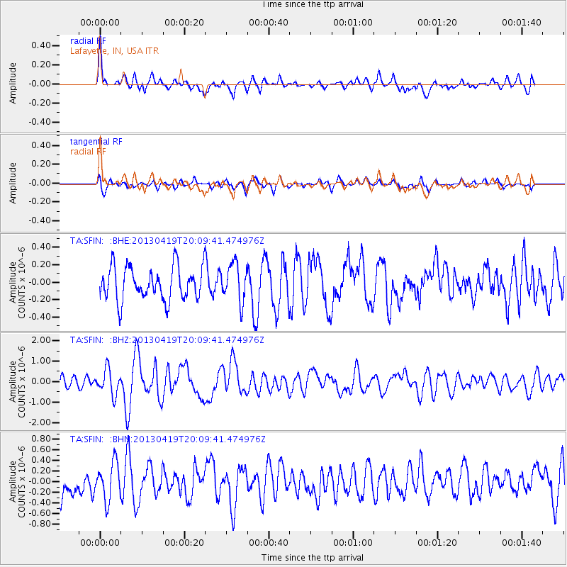
SFIN Lafayette, IN, USA - Earthquake Result Viewer
*The percent match for this event was below the threshold and hence no stack was calculated.
| Earthquake location: |
East Of Kuril Islands |
| Earthquake latitude/longitude: |
50.0/157.7 |
| Earthquake time(UTC): |
2013/04/19 (109) 19:58:40 GMT |
| Earthquake Depth: |
15 km |
| Earthquake Magnitude: |
6.1 MW, 5.9 MB, 6.0 MW, 6.1 MS |
| Earthquake Catalog/Contributor: |
NEIC PDE/NEIC PDE-W |
|
| Network: |
TA USArray Transportable Network (new EarthScope stations) |
| Station: |
SFIN Lafayette, IN, USA |
| Lat/Lon: |
40.38 N/87.10 W |
| Elevation: |
165 m |
|
| Distance: |
73.6 deg |
| Az: |
46.072 deg |
| Baz: |
322.495 deg |
| Ray Param: |
$rayparam |
*The percent match for this event was below the threshold and hence was not used in the summary stack. |
|
| Radial Match: |
75.661224 % |
| Radial Bump: |
400 |
| Transverse Match: |
65.93862 % |
| Transverse Bump: |
400 |
| SOD ConfigId: |
512894 |
| Insert Time: |
2013-09-13 13:00:25.677 +0000 |
| GWidth: |
2.5 |
| Max Bumps: |
400 |
| Tol: |
0.001 |
|
Signal To Noise
| Channel | StoN | STA | LTA |
| TA:SFIN: :BHZ:20130419T20:09:41.474976Z | 2.6645799 | 6.272973E-7 | 2.3542071E-7 |
| TA:SFIN: :BHN:20130419T20:09:41.474976Z | 1.7880095 | 3.5713418E-7 | 1.9973841E-7 |
| TA:SFIN: :BHE:20130419T20:09:41.474976Z | 1.1791074 | 2.2312794E-7 | 1.8923461E-7 |
| Arrivals |
| Ps | |
| PpPs | |
| PsPs/PpSs | |


