You are here: Home > Network List > TA - USArray Transportable Network (new EarthScope stations) Stations List
> Station W48A Pulaski, TN, USA > Earthquake Result Viewer
W48A Pulaski, TN, USA - Earthquake Result Viewer

| Earthquake location: |
East Of Kuril Islands |
| Earthquake latitude/longitude: |
50.0/157.7 |
| Earthquake time(UTC): |
2013/04/19 (109) 19:58:40 GMT |
| Earthquake Depth: |
15 km |
| Earthquake Magnitude: |
6.1 MW, 5.9 MB, 6.0 MW, 6.1 MS |
| Earthquake Catalog/Contributor: |
NEIC PDE/NEIC PDE-W |
|
| Network: |
TA USArray Transportable Network (new EarthScope stations) |
| Station: |
W48A Pulaski, TN, USA |
| Lat/Lon: |
35.14 N/86.93 W |
| Elevation: |
260 m |
|
| Distance: |
77.9 deg |
| Az: |
49.218 deg |
| Baz: |
323.371 deg |
| Ray Param: |
0.050026983 |
| Estimated Moho Depth: |
51.5 km |
| Estimated Crust Vp/Vs: |
1.85 |
| Assumed Crust Vp: |
6.476 km/s |
| Estimated Crust Vs: |
3.5 km/s |
| Estimated Crust Poisson's Ratio: |
0.29 |
|
| Radial Match: |
89.79295 % |
| Radial Bump: |
338 |
| Transverse Match: |
72.98436 % |
| Transverse Bump: |
400 |
| SOD ConfigId: |
512894 |
| Insert Time: |
2013-09-13 13:03:22.859 +0000 |
| GWidth: |
2.5 |
| Max Bumps: |
400 |
| Tol: |
0.001 |
|
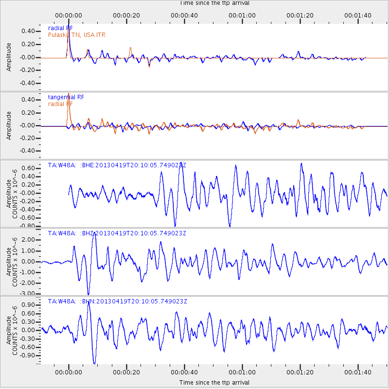
Signal To Noise
| Channel | StoN | STA | LTA |
| TA:W48A: :BHZ:20130419T20:10:05.749023Z | 4.93325 | 8.118385E-7 | 1.6456464E-7 |
| TA:W48A: :BHN:20130419T20:10:05.749023Z | 2.5142827 | 2.7470105E-7 | 1.0925623E-7 |
| TA:W48A: :BHE:20130419T20:10:05.749023Z | 2.7515144 | 2.936638E-7 | 1.0672805E-7 |
| Arrivals |
| Ps | 7.0 SECOND |
| PpPs | 22 SECOND |
| PsPs/PpSs | 29 SECOND |


