You are here: Home > Network List > TA - USArray Transportable Network (new EarthScope stations) Stations List
> Station W54A Cherokee Point, Campobello, SC, USA > Earthquake Result Viewer
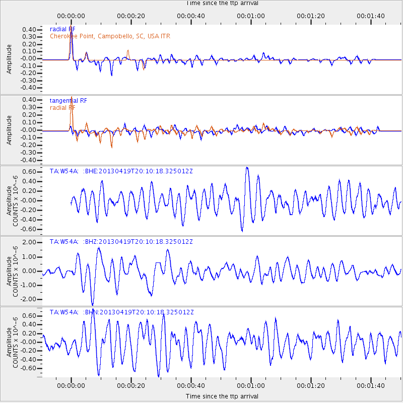
W54A Cherokee Point, Campobello, SC, USA - Earthquake Result Viewer
*The percent match for this event was below the threshold and hence no stack was calculated.
| Earthquake location: |
East Of Kuril Islands |
| Earthquake latitude/longitude: |
50.0/157.7 |
| Earthquake time(UTC): |
2013/04/19 (109) 19:58:40 GMT |
| Earthquake Depth: |
15 km |
| Earthquake Magnitude: |
6.1 MW, 5.9 MB, 6.0 MW, 6.1 MS |
| Earthquake Catalog/Contributor: |
NEIC PDE/NEIC PDE-W |
|
| Network: |
TA USArray Transportable Network (new EarthScope stations) |
| Station: |
W54A Cherokee Point, Campobello, SC, USA |
| Lat/Lon: |
35.09 N/82.19 W |
| Elevation: |
272 m |
|
| Distance: |
80.2 deg |
| Az: |
46.025 deg |
| Baz: |
325.481 deg |
| Ray Param: |
$rayparam |
*The percent match for this event was below the threshold and hence was not used in the summary stack. |
|
| Radial Match: |
78.30088 % |
| Radial Bump: |
285 |
| Transverse Match: |
58.41288 % |
| Transverse Bump: |
400 |
| SOD ConfigId: |
512894 |
| Insert Time: |
2013-09-13 13:03:40.996 +0000 |
| GWidth: |
2.5 |
| Max Bumps: |
400 |
| Tol: |
0.001 |
|
Signal To Noise
| Channel | StoN | STA | LTA |
| TA:W54A: :BHZ:20130419T20:10:18.325012Z | 3.8730657 | 7.621301E-7 | 1.9677697E-7 |
| TA:W54A: :BHN:20130419T20:10:18.325012Z | 1.5978833 | 2.3482151E-7 | 1.4695786E-7 |
| TA:W54A: :BHE:20130419T20:10:18.325012Z | 0.87546533 | 1.6001825E-7 | 1.827808E-7 |
| Arrivals |
| Ps | |
| PpPs | |
| PsPs/PpSs | |


