You are here: Home > Network List > TA - USArray Transportable Network (new EarthScope stations) Stations List
> Station X49A Woodville, AR, USA > Earthquake Result Viewer
X49A Woodville, AR, USA - Earthquake Result Viewer
| Earthquake location: |
East Of Kuril Islands |
| Earthquake latitude/longitude: |
50.0/157.7 |
| Earthquake time(UTC): |
2013/04/19 (109) 19:58:40 GMT |
| Earthquake Depth: |
15 km |
| Earthquake Magnitude: |
6.1 MW, 5.9 MB, 6.0 MW, 6.1 MS |
| Earthquake Catalog/Contributor: |
NEIC PDE/NEIC PDE-W |
|
| Network: |
TA USArray Transportable Network (new EarthScope stations) |
| Station: |
X49A Woodville, AR, USA |
| Lat/Lon: |
34.51 N/86.33 W |
| Elevation: |
182 m |
|
| Distance: |
78.7 deg |
| Az: |
49.187 deg |
| Baz: |
323.709 deg |
| Ray Param: |
0.049483076 |
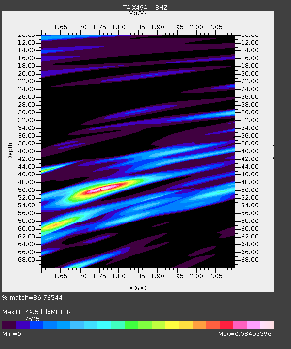
| Estimated Moho Depth: |
49.5 km |
| Estimated Crust Vp/Vs: |
1.75 |
| Assumed Crust Vp: |
6.476 km/s |
| Estimated Crust Vs: |
3.695 km/s |
| Estimated Crust Poisson's Ratio: |
0.26 |
|
| Radial Match: |
86.76544 % |
| Radial Bump: |
399 |
| Transverse Match: |
53.252388 % |
| Transverse Bump: |
400 |
| SOD ConfigId: |
512894 |
| Insert Time: |
2013-09-13 13:04:15.639 +0000 |
| GWidth: |
2.5 |
| Max Bumps: |
400 |
| Tol: |
0.001 |
|
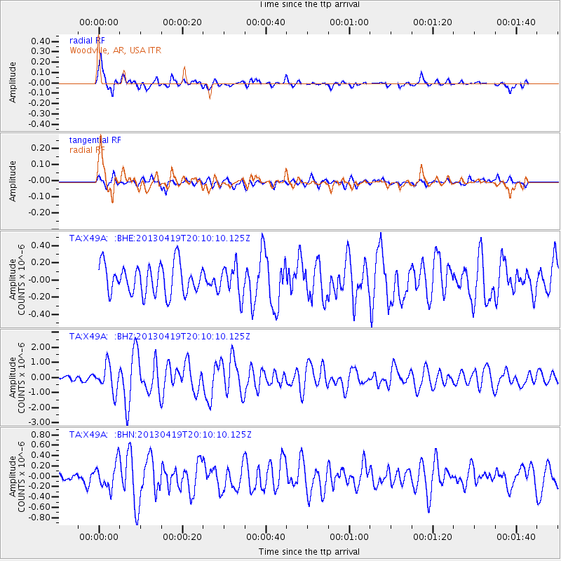
Signal To Noise
| Channel | StoN | STA | LTA |
| TA:X49A: :BHZ:20130419T20:10:10.125Z | 6.738414 | 8.864597E-7 | 1.3155318E-7 |
| TA:X49A: :BHN:20130419T20:10:10.125Z | 2.3779325 | 2.5498008E-7 | 1.07227635E-7 |
| TA:X49A: :BHE:20130419T20:10:10.125Z | 1.0321201 | 1.7729879E-7 | 1.7178115E-7 |
| Arrivals |
| Ps | 5.9 SECOND |
| PpPs | 20 SECOND |
| PsPs/PpSs | 26 SECOND |


