You are here: Home > Network List > TA - USArray Transportable Network (new EarthScope stations) Stations List
> Station Y50A Piedmont, AL, USA > Earthquake Result Viewer
Y50A Piedmont, AL, USA - Earthquake Result Viewer
| Earthquake location: |
East Of Kuril Islands |
| Earthquake latitude/longitude: |
50.0/157.7 |
| Earthquake time(UTC): |
2013/04/19 (109) 19:58:40 GMT |
| Earthquake Depth: |
15 km |
| Earthquake Magnitude: |
6.1 MW, 5.9 MB, 6.0 MW, 6.1 MS |
| Earthquake Catalog/Contributor: |
NEIC PDE/NEIC PDE-W |
|
| Network: |
TA USArray Transportable Network (new EarthScope stations) |
| Station: |
Y50A Piedmont, AL, USA |
| Lat/Lon: |
33.89 N/85.73 W |
| Elevation: |
248 m |
|
| Distance: |
79.4 deg |
| Az: |
49.156 deg |
| Baz: |
324.034 deg |
| Ray Param: |
0.048945308 |
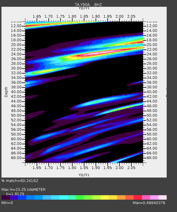
| Estimated Moho Depth: |
23.25 km |
| Estimated Crust Vp/Vs: |
1.91 |
| Assumed Crust Vp: |
6.719 km/s |
| Estimated Crust Vs: |
3.513 km/s |
| Estimated Crust Poisson's Ratio: |
0.31 |
|
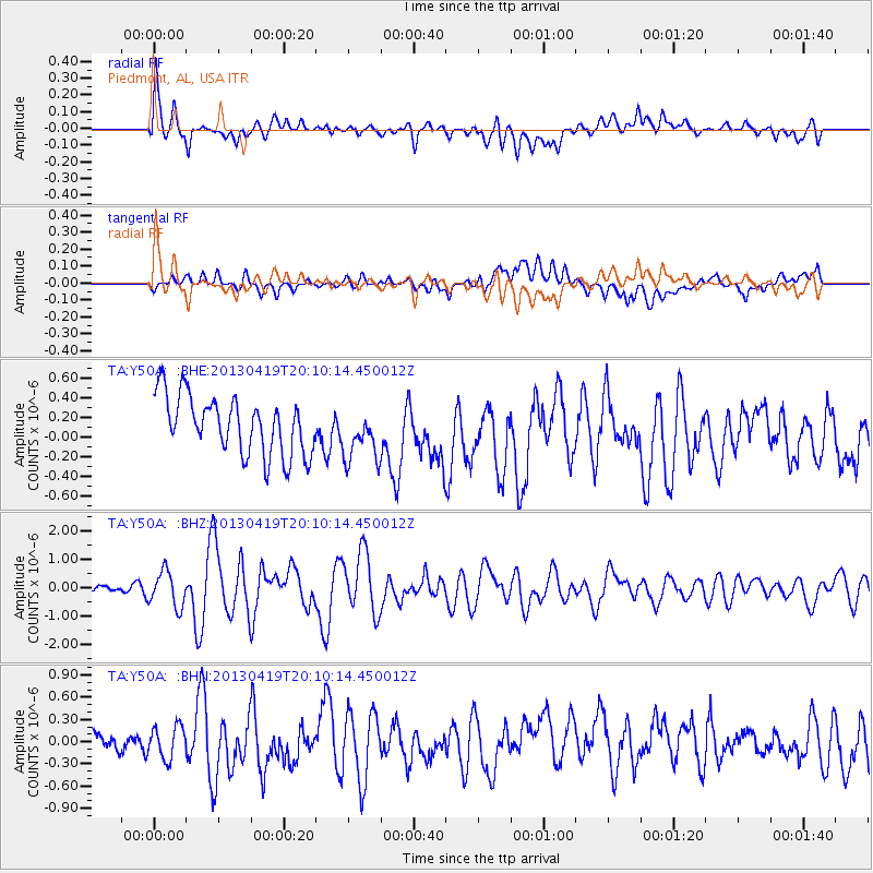
| Radial Match: |
80.24182 % |
| Radial Bump: |
400 |
| Transverse Match: |
38.7185 % |
| Transverse Bump: |
400 |
| SOD ConfigId: |
512894 |
| Insert Time: |
2013-09-13 13:04:54.992 +0000 |
| GWidth: |
2.5 |
| Max Bumps: |
400 |
| Tol: |
0.001 |
|
Signal To Noise
| Channel | StoN | STA | LTA |
| TA:Y50A: :BHZ:20130419T20:10:14.450012Z | 1.8830318 | 6.2752076E-7 | 3.332502E-7 |
| TA:Y50A: :BHN:20130419T20:10:14.450012Z | 0.75717396 | 2.2071536E-7 | 2.9149888E-7 |
| TA:Y50A: :BHE:20130419T20:10:14.450012Z | 0.93228734 | 2.7664987E-7 | 2.9674314E-7 |
| Arrivals |
| Ps | 3.3 SECOND |
| PpPs | 9.8 SECOND |
| PsPs/PpSs | 13 SECOND |


