You are here: Home > Network List > TA - USArray Transportable Network (new EarthScope stations) Stations List
> Station Y57A Sumter, SC, USA > Earthquake Result Viewer
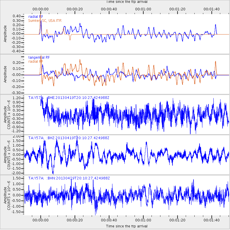
Y57A Sumter, SC, USA - Earthquake Result Viewer
*The percent match for this event was below the threshold and hence no stack was calculated.
| Earthquake location: |
East Of Kuril Islands |
| Earthquake latitude/longitude: |
50.0/157.7 |
| Earthquake time(UTC): |
2013/04/19 (109) 19:58:40 GMT |
| Earthquake Depth: |
15 km |
| Earthquake Magnitude: |
6.1 MW, 5.9 MB, 6.0 MW, 6.1 MS |
| Earthquake Catalog/Contributor: |
NEIC PDE/NEIC PDE-W |
|
| Network: |
TA USArray Transportable Network (new EarthScope stations) |
| Station: |
Y57A Sumter, SC, USA |
| Lat/Lon: |
34.02 N/80.39 W |
| Elevation: |
56 m |
|
| Distance: |
81.9 deg |
| Az: |
45.387 deg |
| Baz: |
326.395 deg |
| Ray Param: |
$rayparam |
*The percent match for this event was below the threshold and hence was not used in the summary stack. |
|
| Radial Match: |
61.145756 % |
| Radial Bump: |
400 |
| Transverse Match: |
50.202805 % |
| Transverse Bump: |
400 |
| SOD ConfigId: |
512894 |
| Insert Time: |
2013-09-13 13:05:14.822 +0000 |
| GWidth: |
2.5 |
| Max Bumps: |
400 |
| Tol: |
0.001 |
|
Signal To Noise
| Channel | StoN | STA | LTA |
| TA:Y57A: :BHZ:20130419T20:10:27.424988Z | 2.5332801 | 8.4755845E-7 | 3.3456956E-7 |
| TA:Y57A: :BHN:20130419T20:10:27.424988Z | 1.0030103 | 3.7224143E-7 | 3.7112426E-7 |
| TA:Y57A: :BHE:20130419T20:10:27.424988Z | 1.0639409 | 4.7117817E-7 | 4.4286122E-7 |
| Arrivals |
| Ps | |
| PpPs | |
| PsPs/PpSs | |


