You are here: Home > Network List > US - United States National Seismic Network Stations List
> Station AHID Auburn Hatchery, Idaho, USA > Earthquake Result Viewer
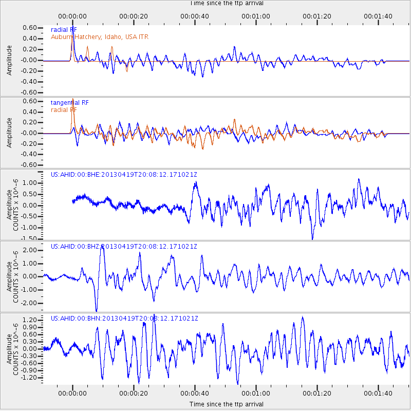
AHID Auburn Hatchery, Idaho, USA - Earthquake Result Viewer
*The percent match for this event was below the threshold and hence no stack was calculated.
| Earthquake location: |
East Of Kuril Islands |
| Earthquake latitude/longitude: |
50.0/157.7 |
| Earthquake time(UTC): |
2013/04/19 (109) 19:58:40 GMT |
| Earthquake Depth: |
15 km |
| Earthquake Magnitude: |
6.1 MW, 5.9 MB, 6.0 MW, 6.1 MS |
| Earthquake Catalog/Contributor: |
NEIC PDE/NEIC PDE-W |
|
| Network: |
US United States National Seismic Network |
| Station: |
AHID Auburn Hatchery, Idaho, USA |
| Lat/Lon: |
42.77 N/111.10 W |
| Elevation: |
1960 m |
|
| Distance: |
59.6 deg |
| Az: |
58.615 deg |
| Baz: |
311.528 deg |
| Ray Param: |
$rayparam |
*The percent match for this event was below the threshold and hence was not used in the summary stack. |
|
| Radial Match: |
67.763794 % |
| Radial Bump: |
400 |
| Transverse Match: |
69.24817 % |
| Transverse Bump: |
400 |
| SOD ConfigId: |
512894 |
| Insert Time: |
2013-09-13 13:06:33.527 +0000 |
| GWidth: |
2.5 |
| Max Bumps: |
400 |
| Tol: |
0.001 |
|
Signal To Noise
| Channel | StoN | STA | LTA |
| US:AHID:00:BHZ:20130419T20:08:12.171021Z | 2.559293 | 2.6247366E-7 | 1.025571E-7 |
| US:AHID:00:BHN:20130419T20:08:12.171021Z | 0.7270355 | 1.801834E-7 | 2.4783301E-7 |
| US:AHID:00:BHE:20130419T20:08:12.171021Z | 1.4426671 | 2.4894672E-7 | 1.7256004E-7 |
| Arrivals |
| Ps | |
| PpPs | |
| PsPs/PpSs | |


