You are here: Home > Network List > WY - Yellowstone Wyoming Seismic Network Stations List
> Station YHL Hebgen Lake, YNP, WY, USA > Earthquake Result Viewer
YHL Hebgen Lake, YNP, WY, USA - Earthquake Result Viewer
| Earthquake location: |
East Of Kuril Islands |
| Earthquake latitude/longitude: |
50.0/157.7 |
| Earthquake time(UTC): |
2013/04/19 (109) 19:58:40 GMT |
| Earthquake Depth: |
15 km |
| Earthquake Magnitude: |
6.1 MW, 5.9 MB, 6.0 MW, 6.1 MS |
| Earthquake Catalog/Contributor: |
NEIC PDE/NEIC PDE-W |
|
| Network: |
WY Yellowstone Wyoming Seismic Network |
| Station: |
YHL Hebgen Lake, YNP, WY, USA |
| Lat/Lon: |
44.85 N/111.18 W |
| Elevation: |
2691 m |
|
| Distance: |
58.2 deg |
| Az: |
56.824 deg |
| Baz: |
310.545 deg |
| Ray Param: |
0.06300413 |
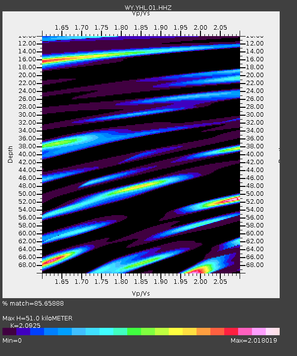
| Estimated Moho Depth: |
51.0 km |
| Estimated Crust Vp/Vs: |
2.09 |
| Assumed Crust Vp: |
6.35 km/s |
| Estimated Crust Vs: |
3.035 km/s |
| Estimated Crust Poisson's Ratio: |
0.35 |
|
| Radial Match: |
85.65888 % |
| Radial Bump: |
400 |
| Transverse Match: |
81.365944 % |
| Transverse Bump: |
400 |
| SOD ConfigId: |
512894 |
| Insert Time: |
2013-09-13 13:11:50.774 +0000 |
| GWidth: |
2.5 |
| Max Bumps: |
400 |
| Tol: |
0.001 |
|

Signal To Noise
| Channel | StoN | STA | LTA |
| WY:YHL:01:HHZ:20130419T20:08:02.367981Z | 3.4643033 | 7.474185E-9 | 2.1574855E-9 |
| WY:YHL:01:HHN:20130419T20:08:02.367981Z | 2.4238584 | 5.414115E-9 | 2.2336764E-9 |
| WY:YHL:01:HHE:20130419T20:08:02.367981Z | 1.2561513 | 4.3019894E-9 | 3.4247383E-9 |
| Arrivals |
| Ps | 9.1 SECOND |
| PpPs | 24 SECOND |
| PsPs/PpSs | 33 SECOND |


