You are here: Home > Network List > TA - USArray Transportable Network (new EarthScope stations) Stations List
> Station G59A Clarenceville, QC, USA > Earthquake Result Viewer
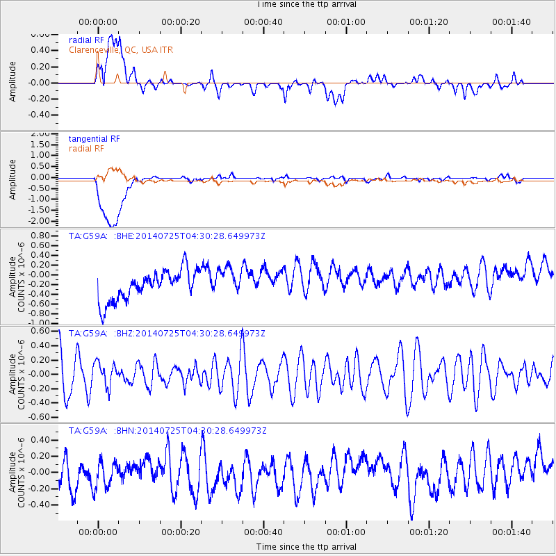
G59A Clarenceville, QC, USA - Earthquake Result Viewer
*The percent match for this event was below the threshold and hence no stack was calculated.
| Earthquake location: |
Hokkaido, Japan Region |
| Earthquake latitude/longitude: |
41.6/142.2 |
| Earthquake time(UTC): |
2014/07/25 (206) 04:18:16 GMT |
| Earthquake Depth: |
64 km |
| Earthquake Magnitude: |
5.0 MW, 5.1 mb |
| Earthquake Catalog/Contributor: |
ISC/ISC |
|
| Network: |
TA USArray Transportable Network (new EarthScope stations) |
| Station: |
G59A Clarenceville, QC, USA |
| Lat/Lon: |
45.08 N/73.18 W |
| Elevation: |
36 m |
|
| Distance: |
88.1 deg |
| Az: |
24.228 deg |
| Baz: |
334.239 deg |
| Ray Param: |
$rayparam |
*The percent match for this event was below the threshold and hence was not used in the summary stack. |
|
| Radial Match: |
25.41364 % |
| Radial Bump: |
400 |
| Transverse Match: |
23.74445 % |
| Transverse Bump: |
400 |
| SOD ConfigId: |
3390531 |
| Insert Time: |
2019-04-13 00:37:49.944 +0000 |
| GWidth: |
2.5 |
| Max Bumps: |
400 |
| Tol: |
0.001 |
|
Signal To Noise
| Channel | StoN | STA | LTA |
| TA:G59A: :BHZ:20140725T04:30:28.649973Z | 0.57298607 | 1.6514612E-7 | 2.8822012E-7 |
| TA:G59A: :BHN:20140725T04:30:28.649973Z | 0.7167615 | 1.8243306E-7 | 2.5452405E-7 |
| TA:G59A: :BHE:20140725T04:30:28.649973Z | 0.9811219 | 2.9720545E-7 | 3.029241E-7 |
| Arrivals |
| Ps | |
| PpPs | |
| PsPs/PpSs | |


