You are here: Home > Network List > TA - USArray Transportable Network (new EarthScope stations) Stations List
> Station R11A Troy Canyon, Currant, NV, USA > Earthquake Result Viewer
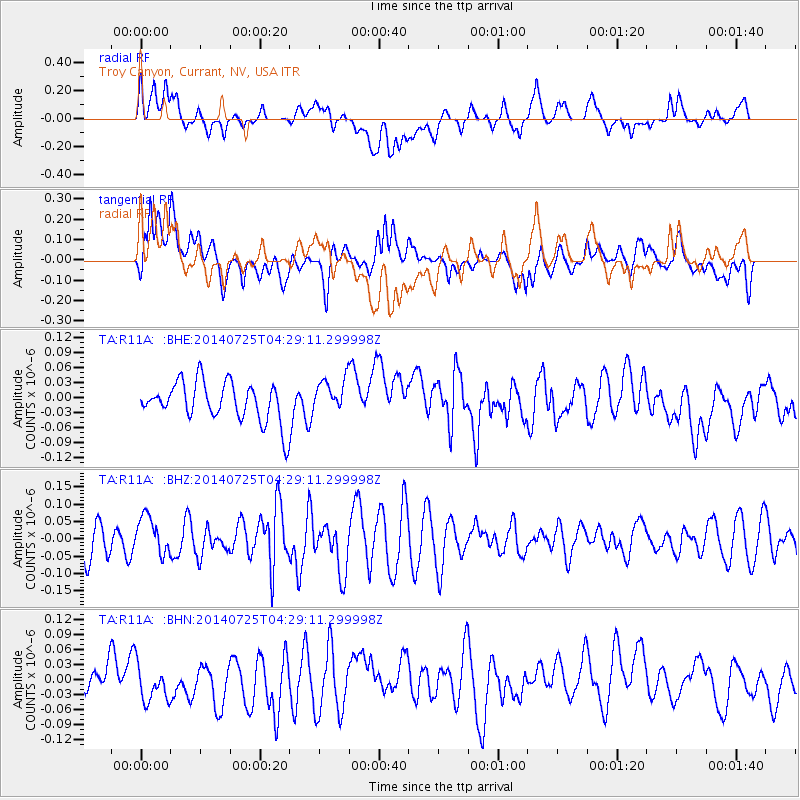
R11A Troy Canyon, Currant, NV, USA - Earthquake Result Viewer
*The percent match for this event was below the threshold and hence no stack was calculated.
| Earthquake location: |
Hokkaido, Japan Region |
| Earthquake latitude/longitude: |
41.6/142.2 |
| Earthquake time(UTC): |
2014/07/25 (206) 04:18:16 GMT |
| Earthquake Depth: |
64 km |
| Earthquake Magnitude: |
5.0 MW, 5.1 mb |
| Earthquake Catalog/Contributor: |
ISC/ISC |
|
| Network: |
TA USArray Transportable Network (new EarthScope stations) |
| Station: |
R11A Troy Canyon, Currant, NV, USA |
| Lat/Lon: |
38.35 N/115.59 W |
| Elevation: |
1756 m |
|
| Distance: |
73.5 deg |
| Az: |
53.258 deg |
| Baz: |
310.117 deg |
| Ray Param: |
$rayparam |
*The percent match for this event was below the threshold and hence was not used in the summary stack. |
|
| Radial Match: |
48.919125 % |
| Radial Bump: |
400 |
| Transverse Match: |
58.625847 % |
| Transverse Bump: |
400 |
| SOD ConfigId: |
3390531 |
| Insert Time: |
2019-04-13 00:38:26.781 +0000 |
| GWidth: |
2.5 |
| Max Bumps: |
400 |
| Tol: |
0.001 |
|
Signal To Noise
| Channel | StoN | STA | LTA |
| TA:R11A: :BHZ:20140725T04:29:11.299998Z | 1.000872 | 5.500367E-8 | 5.4955752E-8 |
| TA:R11A: :BHN:20140725T04:29:11.299998Z | 0.9722598 | 4.682612E-8 | 4.8162146E-8 |
| TA:R11A: :BHE:20140725T04:29:11.299998Z | 0.8863431 | 3.41762E-8 | 3.855866E-8 |
| Arrivals |
| Ps | |
| PpPs | |
| PsPs/PpSs | |


