You are here: Home > Network List > CN - Canadian National Seismograph Network Stations List
> Station INK INUVIK, NT > Earthquake Result Viewer
INK INUVIK, NT - Earthquake Result Viewer
| Earthquake location: |
Sichuan, China |
| Earthquake latitude/longitude: |
30.3/102.9 |
| Earthquake time(UTC): |
2013/04/20 (110) 00:02:47 GMT |
| Earthquake Depth: |
14 km |
| Earthquake Magnitude: |
6.6 MW, 6.5 MB, 6.6 MW, 6.8 MS |
| Earthquake Catalog/Contributor: |
NEIC PDE/NEIC PDE-W |
|
| Network: |
CN Canadian National Seismograph Network |
| Station: |
INK INUVIK, NT |
| Lat/Lon: |
68.31 N/133.53 W |
| Elevation: |
44 m |
|
| Distance: |
73.2 deg |
| Az: |
18.872 deg |
| Baz: |
311.205 deg |
| Ray Param: |
0.053122945 |
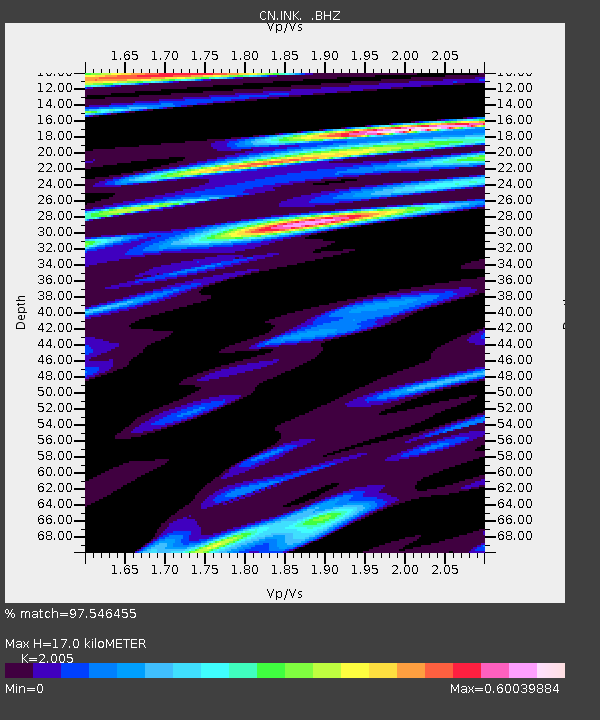
| Estimated Moho Depth: |
17.0 km |
| Estimated Crust Vp/Vs: |
2.01 |
| Assumed Crust Vp: |
6.171 km/s |
| Estimated Crust Vs: |
3.078 km/s |
| Estimated Crust Poisson's Ratio: |
0.33 |
|
| Radial Match: |
97.546455 % |
| Radial Bump: |
400 |
| Transverse Match: |
92.64511 % |
| Transverse Bump: |
400 |
| SOD ConfigId: |
512894 |
| Insert Time: |
2013-09-13 13:21:13.423 +0000 |
| GWidth: |
2.5 |
| Max Bumps: |
400 |
| Tol: |
0.001 |
|
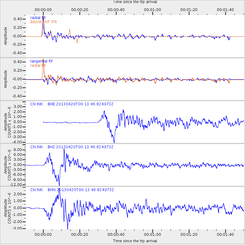
Signal To Noise
| Channel | StoN | STA | LTA |
| CN:INK: :BHZ:20130420T00:13:46.824973Z | 48.269142 | 3.0718093E-6 | 6.363919E-8 |
| CN:INK: :BHN:20130420T00:13:46.824973Z | 9.634731 | 7.5588434E-7 | 7.8454114E-8 |
| CN:INK: :BHE:20130420T00:13:46.824973Z | 21.859076 | 1.0447635E-6 | 4.7795414E-8 |
| Arrivals |
| Ps | 2.8 SECOND |
| PpPs | 8.1 SECOND |
| PsPs/PpSs | 11 SECOND |


