You are here: Home > Network List > G - GEOSCOPE Stations List
> Station ATD Arta Cave - Arta, Republic of Djibouti > Earthquake Result Viewer
ATD Arta Cave - Arta, Republic of Djibouti - Earthquake Result Viewer
| Earthquake location: |
Sichuan, China |
| Earthquake latitude/longitude: |
30.3/102.9 |
| Earthquake time(UTC): |
2013/04/20 (110) 00:02:47 GMT |
| Earthquake Depth: |
14 km |
| Earthquake Magnitude: |
6.6 MW, 6.5 MB, 6.6 MW, 6.8 MS |
| Earthquake Catalog/Contributor: |
NEIC PDE/NEIC PDE-W |
|
| Network: |
G GEOSCOPE |
| Station: |
ATD Arta Cave - Arta, Republic of Djibouti |
| Lat/Lon: |
11.53 N/42.85 E |
| Elevation: |
610 m |
|
| Distance: |
58.5 deg |
| Az: |
265.02 deg |
| Baz: |
61.527 deg |
| Ray Param: |
0.062815905 |
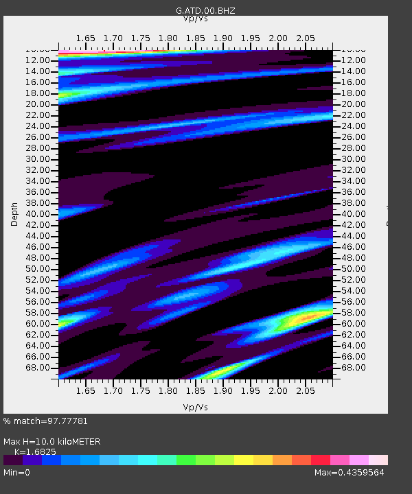
| Estimated Moho Depth: |
10.0 km |
| Estimated Crust Vp/Vs: |
1.68 |
| Assumed Crust Vp: |
6.375 km/s |
| Estimated Crust Vs: |
3.789 km/s |
| Estimated Crust Poisson's Ratio: |
0.23 |
|
| Radial Match: |
97.77781 % |
| Radial Bump: |
297 |
| Transverse Match: |
87.80705 % |
| Transverse Bump: |
400 |
| SOD ConfigId: |
512894 |
| Insert Time: |
2013-09-13 13:22:52.747 +0000 |
| GWidth: |
2.5 |
| Max Bumps: |
400 |
| Tol: |
0.001 |
|
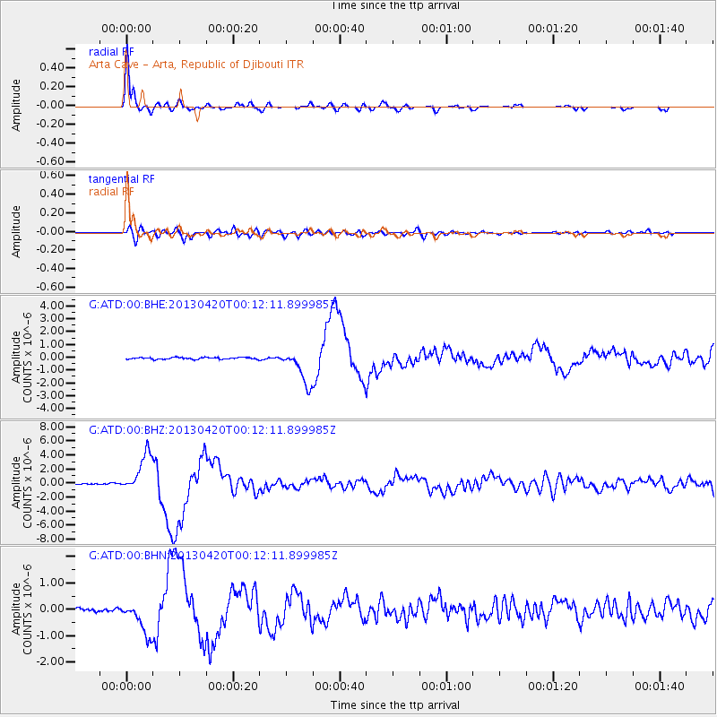
Signal To Noise
| Channel | StoN | STA | LTA |
| G:ATD:00:BHZ:20130420T00:12:11.899985Z | 41.7881 | 2.8518368E-6 | 6.824519E-8 |
| G:ATD:00:BHN:20130420T00:12:11.899985Z | 10.170716 | 6.601471E-7 | 6.490665E-8 |
| G:ATD:00:BHE:20130420T00:12:11.899985Z | 18.653847 | 1.357703E-6 | 7.2784076E-8 |
| Arrivals |
| Ps | 1.1 SECOND |
| PpPs | 4.0 SECOND |
| PsPs/PpSs | 5.1 SECOND |


