You are here: Home > Network List > G - GEOSCOPE Stations List
> Station TAM Tamanrasset, Algeria > Earthquake Result Viewer
TAM Tamanrasset, Algeria - Earthquake Result Viewer
| Earthquake location: |
Sichuan, China |
| Earthquake latitude/longitude: |
30.3/102.9 |
| Earthquake time(UTC): |
2013/04/20 (110) 00:02:47 GMT |
| Earthquake Depth: |
14 km |
| Earthquake Magnitude: |
6.6 MW, 6.5 MB, 6.6 MW, 6.8 MS |
| Earthquake Catalog/Contributor: |
NEIC PDE/NEIC PDE-W |
|
| Network: |
G GEOSCOPE |
| Station: |
TAM Tamanrasset, Algeria |
| Lat/Lon: |
22.79 N/5.53 E |
| Elevation: |
1377 m |
|
| Distance: |
84.8 deg |
| Az: |
293.21 deg |
| Baz: |
59.458 deg |
| Ray Param: |
0.04523725 |
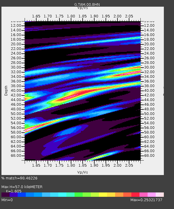
| Estimated Moho Depth: |
57.0 km |
| Estimated Crust Vp/Vs: |
1.61 |
| Assumed Crust Vp: |
6.61 km/s |
| Estimated Crust Vs: |
4.118 km/s |
| Estimated Crust Poisson's Ratio: |
0.18 |
|
| Radial Match: |
98.46226 % |
| Radial Bump: |
262 |
| Transverse Match: |
76.31051 % |
| Transverse Bump: |
400 |
| SOD ConfigId: |
512894 |
| Insert Time: |
2013-09-13 13:23:13.955 +0000 |
| GWidth: |
2.5 |
| Max Bumps: |
400 |
| Tol: |
0.001 |
|
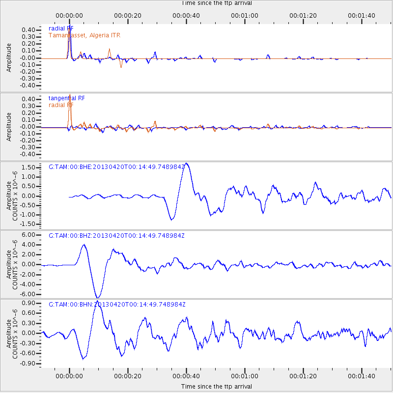
Signal To Noise
| Channel | StoN | STA | LTA |
| G:TAM:00:BHZ:20130420T00:14:49.748984Z | 32.124767 | 1.7525067E-6 | 5.4553134E-8 |
| G:TAM:00:BHN:20130420T00:14:49.748984Z | 5.464895 | 3.4090007E-7 | 6.237999E-8 |
| G:TAM:00:BHE:20130420T00:14:49.748984Z | 7.6832175 | 4.88211E-7 | 6.354252E-8 |
| Arrivals |
| Ps | 5.4 SECOND |
| PpPs | 22 SECOND |
| PsPs/PpSs | 27 SECOND |


