You are here: Home > Network List > IU - Global Seismograph Network (GSN - IRIS/USGS) Stations List
> Station GUMO Guam, Mariana Islands > Earthquake Result Viewer
GUMO Guam, Mariana Islands - Earthquake Result Viewer
| Earthquake location: |
Sichuan, China |
| Earthquake latitude/longitude: |
30.3/102.9 |
| Earthquake time(UTC): |
2013/04/20 (110) 00:02:47 GMT |
| Earthquake Depth: |
14 km |
| Earthquake Magnitude: |
6.6 MW, 6.5 MB, 6.6 MW, 6.8 MS |
| Earthquake Catalog/Contributor: |
NEIC PDE/NEIC PDE-W |
|
| Network: |
IU Global Seismograph Network (GSN - IRIS/USGS) |
| Station: |
GUMO Guam, Mariana Islands |
| Lat/Lon: |
13.59 N/144.87 E |
| Elevation: |
170 m |
|
| Distance: |
42.1 deg |
| Az: |
103.907 deg |
| Baz: |
300.31 deg |
| Ray Param: |
0.07337892 |
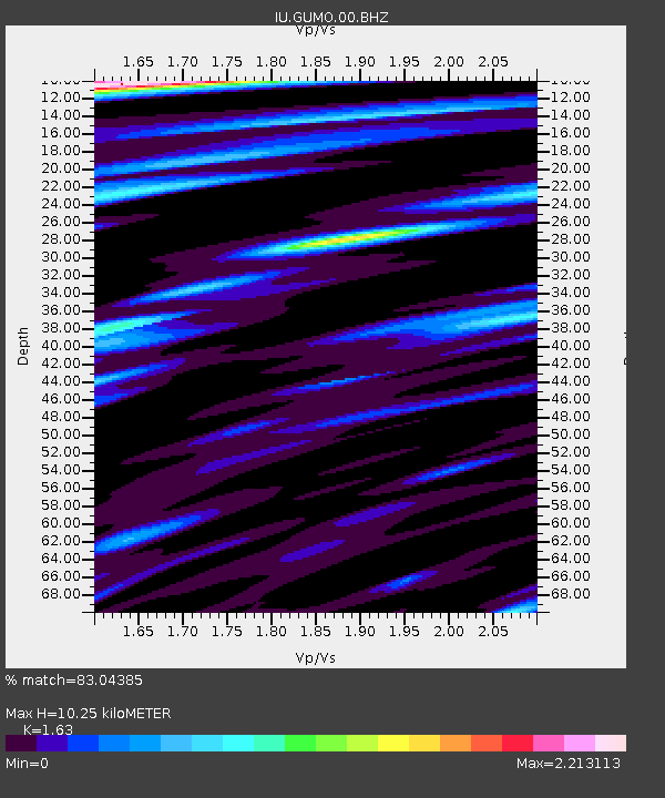
| Estimated Moho Depth: |
10.25 km |
| Estimated Crust Vp/Vs: |
1.63 |
| Assumed Crust Vp: |
4.802 km/s |
| Estimated Crust Vs: |
2.946 km/s |
| Estimated Crust Poisson's Ratio: |
0.20 |
|
| Radial Match: |
83.04385 % |
| Radial Bump: |
400 |
| Transverse Match: |
70.457924 % |
| Transverse Bump: |
400 |
| SOD ConfigId: |
512894 |
| Insert Time: |
2013-09-13 13:27:25.517 +0000 |
| GWidth: |
2.5 |
| Max Bumps: |
400 |
| Tol: |
0.001 |
|

Signal To Noise
| Channel | StoN | STA | LTA |
| IU:GUMO:00:BHZ:20130420T00:10:07.918998Z | 11.961182 | 7.572728E-6 | 6.331087E-7 |
| IU:GUMO:00:BH1:20130420T00:10:07.918998Z | 2.5073984 | 1.3303604E-6 | 5.30574E-7 |
| IU:GUMO:00:BH2:20130420T00:10:07.918998Z | 4.080161 | 2.0868733E-6 | 5.1146833E-7 |
| Arrivals |
| Ps | 1.4 SECOND |
| PpPs | 5.4 SECOND |
| PsPs/PpSs | 6.8 SECOND |


