You are here: Home > Network List > US - United States National Seismic Network Stations List
> Station WRAK Wrangell Island, Southeastern Alaska, Alaska, USA > Earthquake Result Viewer
WRAK Wrangell Island, Southeastern Alaska, Alaska, USA - Earthquake Result Viewer
| Earthquake location: |
Sichuan, China |
| Earthquake latitude/longitude: |
30.3/102.9 |
| Earthquake time(UTC): |
2013/04/20 (110) 00:02:47 GMT |
| Earthquake Depth: |
14 km |
| Earthquake Magnitude: |
6.6 MW, 6.5 MB, 6.6 MW, 6.8 MS |
| Earthquake Catalog/Contributor: |
NEIC PDE/NEIC PDE-W |
|
| Network: |
US United States National Seismic Network |
| Station: |
WRAK Wrangell Island, Southeastern Alaska, Alaska, USA |
| Lat/Lon: |
56.42 N/132.35 W |
| Elevation: |
81 m |
|
| Distance: |
81.8 deg |
| Az: |
27.469 deg |
| Baz: |
314.123 deg |
| Ray Param: |
0.04735778 |
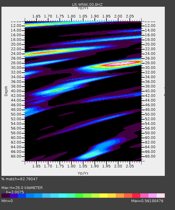
| Estimated Moho Depth: |
28.0 km |
| Estimated Crust Vp/Vs: |
2.01 |
| Assumed Crust Vp: |
6.597 km/s |
| Estimated Crust Vs: |
3.286 km/s |
| Estimated Crust Poisson's Ratio: |
0.33 |
|
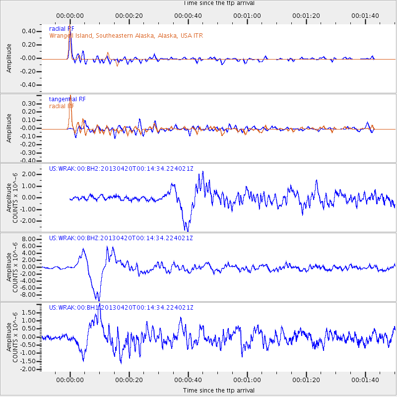
| Radial Match: |
92.79047 % |
| Radial Bump: |
400 |
| Transverse Match: |
78.24284 % |
| Transverse Bump: |
400 |
| SOD ConfigId: |
512894 |
| Insert Time: |
2013-09-13 13:34:19.053 +0000 |
| GWidth: |
2.5 |
| Max Bumps: |
400 |
| Tol: |
0.001 |
|
Signal To Noise
| Channel | StoN | STA | LTA |
| US:WRAK:00:BHZ:20130420T00:14:34.224021Z | 14.014023 | 2.3943157E-6 | 1.7085142E-7 |
| US:WRAK:00:BH1:20130420T00:14:34.224021Z | 4.751992 | 5.704748E-7 | 1.200496E-7 |
| US:WRAK:00:BH2:20130420T00:14:34.224021Z | 3.4305453 | 4.7908424E-7 | 1.396525E-7 |
| Arrivals |
| Ps | 4.4 SECOND |
| PpPs | 12 SECOND |
| PsPs/PpSs | 17 SECOND |


