You are here: Home > Network List > KN - Kyrgyz Seismic Telemetry Network Stations List
> Station EKS2 KN.EKS2 > Earthquake Result Viewer
EKS2 KN.EKS2 - Earthquake Result Viewer
| Earthquake location: |
Southeastern Alaska |
| Earthquake latitude/longitude: |
58.4/-137.1 |
| Earthquake time(UTC): |
2014/07/25 (206) 10:54:49 GMT |
| Earthquake Depth: |
10 km |
| Earthquake Magnitude: |
5.9 MWP |
| Earthquake Catalog/Contributor: |
NEIC PDE/NEIC COMCAT |
|
| Network: |
KN Kyrgyz Seismic Telemetry Network |
| Station: |
EKS2 KN.EKS2 |
| Lat/Lon: |
42.66 N/73.78 E |
| Elevation: |
1360 m |
|
| Distance: |
76.1 deg |
| Az: |
337.027 deg |
| Baz: |
16.197 deg |
| Ray Param: |
0.051217508 |
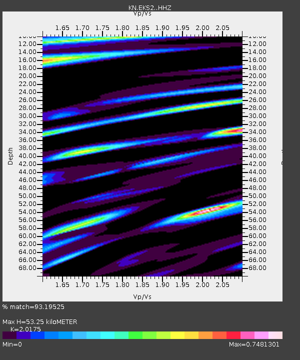
| Estimated Moho Depth: |
53.25 km |
| Estimated Crust Vp/Vs: |
2.02 |
| Assumed Crust Vp: |
6.316 km/s |
| Estimated Crust Vs: |
3.13 km/s |
| Estimated Crust Poisson's Ratio: |
0.34 |
|
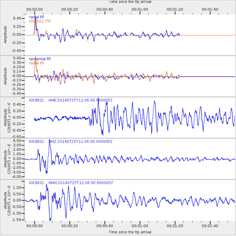
| Radial Match: |
93.19525 % |
| Radial Bump: |
400 |
| Transverse Match: |
84.107056 % |
| Transverse Bump: |
400 |
| SOD ConfigId: |
3390531 |
| Insert Time: |
2019-04-13 00:43:28.831 +0000 |
| GWidth: |
2.5 |
| Max Bumps: |
400 |
| Tol: |
0.001 |
|
Signal To Noise
| Channel | StoN | STA | LTA |
| KN:EKS2: :HHZ:20140725T11:06:06.660005Z | 15.662798 | 9.980743E-7 | 6.37226E-8 |
| KN:EKS2: :HHN:20140725T11:06:06.660005Z | 5.3587866 | 3.200858E-7 | 5.973102E-8 |
| KN:EKS2: :HHE:20140725T11:06:06.660005Z | 3.9301262 | 1.2868789E-7 | 3.274396E-8 |
| Arrivals |
| Ps | 8.8 SECOND |
| PpPs | 25 SECOND |
| PsPs/PpSs | 34 SECOND |


