You are here: Home > Network List > NX - Nanometrics Research Network Stations List
> Station STN20 Seismic station 20 > Earthquake Result Viewer
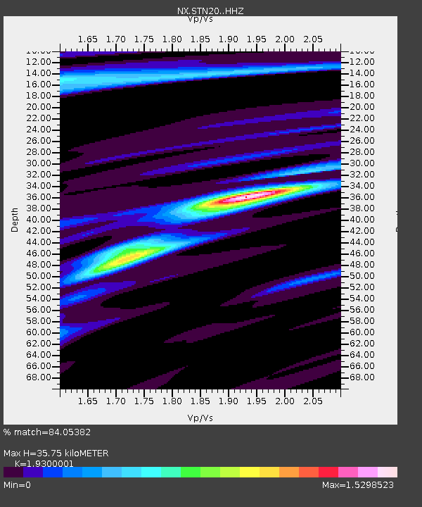
STN20 Seismic station 20 - Earthquake Result Viewer
| Earthquake location: |
Southeastern Alaska |
| Earthquake latitude/longitude: |
58.4/-137.1 |
| Earthquake time(UTC): |
2014/07/25 (206) 10:54:49 GMT |
| Earthquake Depth: |
10 km |
| Earthquake Magnitude: |
5.9 MWP |
| Earthquake Catalog/Contributor: |
NEIC PDE/NEIC COMCAT |
|
| Network: |
NX Nanometrics Research Network |
| Station: |
STN20 Seismic station 20 |
| Lat/Lon: |
36.52 N/97.74 W |
| Elevation: |
339 m |
|
| Distance: |
33.7 deg |
| Az: |
112.972 deg |
| Baz: |
322.949 deg |
| Ray Param: |
0.078076035 |
| Estimated Moho Depth: |
35.75 km |
| Estimated Crust Vp/Vs: |
1.93 |
| Assumed Crust Vp: |
6.483 km/s |
| Estimated Crust Vs: |
3.359 km/s |
| Estimated Crust Poisson's Ratio: |
0.32 |
|
| Radial Match: |
84.05382 % |
| Radial Bump: |
236 |
| Transverse Match: |
52.867203 % |
| Transverse Bump: |
400 |
| SOD ConfigId: |
3390531 |
| Insert Time: |
2019-04-13 00:44:33.856 +0000 |
| GWidth: |
2.5 |
| Max Bumps: |
400 |
| Tol: |
0.001 |
|

Signal To Noise
| Channel | StoN | STA | LTA |
| NX:STN20: :HHZ:20140725T11:00:59.489991Z | 5.2718897 | 7.3566196E-7 | 1.3954426E-7 |
| NX:STN20: :HH1:20140725T11:00:59.489991Z | 1.4046831 | 2.5507188E-7 | 1.8158678E-7 |
| NX:STN20: :HH2:20140725T11:00:59.489991Z | 1.7345396 | 4.428322E-7 | 2.5530244E-7 |
| Arrivals |
| Ps | 5.5 SECOND |
| PpPs | 15 SECOND |
| PsPs/PpSs | 21 SECOND |


