You are here: Home > Network List > NX - Nanometrics Research Network Stations List
> Station STN21 Seismic station 21 > Earthquake Result Viewer
STN21 Seismic station 21 - Earthquake Result Viewer
| Earthquake location: |
Southeastern Alaska |
| Earthquake latitude/longitude: |
58.4/-137.1 |
| Earthquake time(UTC): |
2014/07/25 (206) 10:54:49 GMT |
| Earthquake Depth: |
10 km |
| Earthquake Magnitude: |
5.9 MWP |
| Earthquake Catalog/Contributor: |
NEIC PDE/NEIC COMCAT |
|
| Network: |
NX Nanometrics Research Network |
| Station: |
STN21 Seismic station 21 |
| Lat/Lon: |
36.75 N/97.56 W |
| Elevation: |
333 m |
|
| Distance: |
33.6 deg |
| Az: |
112.511 deg |
| Baz: |
322.673 deg |
| Ray Param: |
0.07811979 |
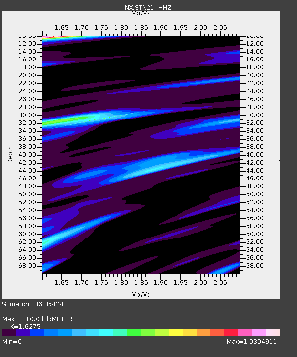
| Estimated Moho Depth: |
10.0 km |
| Estimated Crust Vp/Vs: |
1.63 |
| Assumed Crust Vp: |
6.483 km/s |
| Estimated Crust Vs: |
3.983 km/s |
| Estimated Crust Poisson's Ratio: |
0.20 |
|
| Radial Match: |
86.85424 % |
| Radial Bump: |
266 |
| Transverse Match: |
64.64533 % |
| Transverse Bump: |
400 |
| SOD ConfigId: |
3390531 |
| Insert Time: |
2019-04-13 00:44:34.737 +0000 |
| GWidth: |
2.5 |
| Max Bumps: |
400 |
| Tol: |
0.001 |
|

Signal To Noise
| Channel | StoN | STA | LTA |
| NX:STN21: :HHZ:20140725T11:00:58.670015Z | 4.9678116 | 9.307817E-7 | 1.8736252E-7 |
| NX:STN21: :HH1:20140725T11:00:58.670015Z | 3.0534291 | 4.0043307E-7 | 1.3114209E-7 |
| NX:STN21: :HH2:20140725T11:00:58.670015Z | 1.0987976 | 1.8985256E-7 | 1.7278211E-7 |
| Arrivals |
| Ps | 1.1 SECOND |
| PpPs | 3.7 SECOND |
| PsPs/PpSs | 4.8 SECOND |


