You are here: Home > Network List > US - United States National Seismic Network Stations List
> Station BRAL Brewton, Alabama, USA > Earthquake Result Viewer
BRAL Brewton, Alabama, USA - Earthquake Result Viewer
| Earthquake location: |
Southeastern Alaska |
| Earthquake latitude/longitude: |
58.4/-137.1 |
| Earthquake time(UTC): |
2014/07/25 (206) 10:54:49 GMT |
| Earthquake Depth: |
10 km |
| Earthquake Magnitude: |
5.9 MWP |
| Earthquake Catalog/Contributor: |
NEIC PDE/NEIC COMCAT |
|
| Network: |
US United States National Seismic Network |
| Station: |
BRAL Brewton, Alabama, USA |
| Lat/Lon: |
31.17 N/87.05 W |
| Elevation: |
61 m |
|
| Distance: |
43.3 deg |
| Az: |
106.596 deg |
| Baz: |
323.887 deg |
| Ray Param: |
0.072633065 |
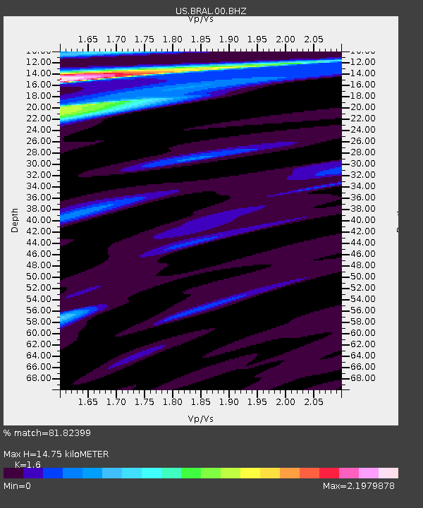
| Estimated Moho Depth: |
14.75 km |
| Estimated Crust Vp/Vs: |
1.60 |
| Assumed Crust Vp: |
6.187 km/s |
| Estimated Crust Vs: |
3.867 km/s |
| Estimated Crust Poisson's Ratio: |
0.18 |
|
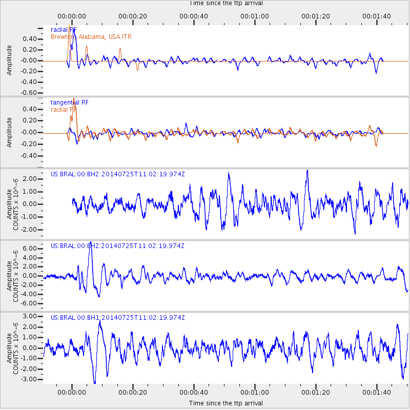
| Radial Match: |
81.82399 % |
| Radial Bump: |
377 |
| Transverse Match: |
52.684753 % |
| Transverse Bump: |
400 |
| SOD ConfigId: |
3390531 |
| Insert Time: |
2019-04-13 00:46:26.672 +0000 |
| GWidth: |
2.5 |
| Max Bumps: |
400 |
| Tol: |
0.001 |
|
Signal To Noise
| Channel | StoN | STA | LTA |
| US:BRAL:00:BHZ:20140725T11:02:19.974Z | 6.650277 | 1.5515842E-6 | 2.333112E-7 |
| US:BRAL:00:BH1:20140725T11:02:19.974Z | 1.2366415 | 5.4465215E-7 | 4.404285E-7 |
| US:BRAL:00:BH2:20140725T11:02:19.974Z | 1.3502649 | 5.6618444E-7 | 4.1931364E-7 |
| Arrivals |
| Ps | 1.5 SECOND |
| PpPs | 5.8 SECOND |
| PsPs/PpSs | 7.3 SECOND |


