You are here: Home > Network List > TA - USArray Transportable Network (new EarthScope stations) Stations List
> Station J04D Umpqua National Forest, Toketee, OR, USA > Earthquake Result Viewer
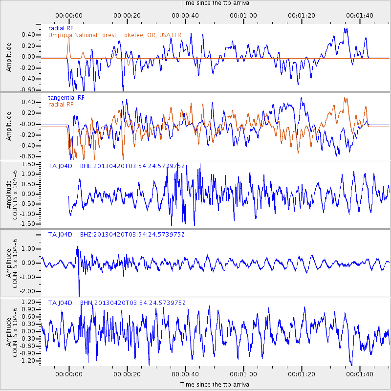
J04D Umpqua National Forest, Toketee, OR, USA - Earthquake Result Viewer
*The percent match for this event was below the threshold and hence no stack was calculated.
| Earthquake location: |
New Britain Region, P.N.G. |
| Earthquake latitude/longitude: |
-5.0/152.1 |
| Earthquake time(UTC): |
2013/04/20 (110) 03:42:02 GMT |
| Earthquake Depth: |
65 km |
| Earthquake Magnitude: |
5.6 MW, 5.6 MB, 5.7 MW |
| Earthquake Catalog/Contributor: |
NEIC PDE/NEIC PDE-W |
|
| Network: |
TA USArray Transportable Network (new EarthScope stations) |
| Station: |
J04D Umpqua National Forest, Toketee, OR, USA |
| Lat/Lon: |
43.24 N/122.11 W |
| Elevation: |
1948 m |
|
| Distance: |
90.3 deg |
| Az: |
46.786 deg |
| Baz: |
263.492 deg |
| Ray Param: |
$rayparam |
*The percent match for this event was below the threshold and hence was not used in the summary stack. |
|
| Radial Match: |
56.7792 % |
| Radial Bump: |
400 |
| Transverse Match: |
61.47082 % |
| Transverse Bump: |
400 |
| SOD ConfigId: |
512894 |
| Insert Time: |
2013-09-13 13:51:27.030 +0000 |
| GWidth: |
2.5 |
| Max Bumps: |
400 |
| Tol: |
0.001 |
|
Signal To Noise
| Channel | StoN | STA | LTA |
| TA:J04D: :BHZ:20130420T03:54:24.573975Z | 4.3708606 | 6.233669E-7 | 1.426188E-7 |
| TA:J04D: :BHN:20130420T03:54:24.573975Z | 0.9086791 | 3.7050498E-7 | 4.0774017E-7 |
| TA:J04D: :BHE:20130420T03:54:24.573975Z | 1.7257501 | 5.829249E-7 | 3.377806E-7 |
| Arrivals |
| Ps | |
| PpPs | |
| PsPs/PpSs | |


