You are here: Home > Network List > TA - USArray Transportable Network (new EarthScope stations) Stations List
> Station O03E Paynes Creek, CA, USA > Earthquake Result Viewer
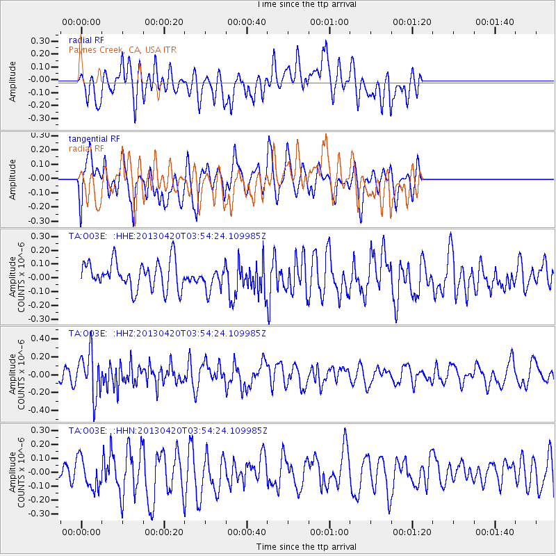
O03E Paynes Creek, CA, USA - Earthquake Result Viewer
*The percent match for this event was below the threshold and hence no stack was calculated.
| Earthquake location: |
New Britain Region, P.N.G. |
| Earthquake latitude/longitude: |
-5.0/152.1 |
| Earthquake time(UTC): |
2013/04/20 (110) 03:42:02 GMT |
| Earthquake Depth: |
65 km |
| Earthquake Magnitude: |
5.6 MW, 5.6 MB, 5.7 MW |
| Earthquake Catalog/Contributor: |
NEIC PDE/NEIC PDE-W |
|
| Network: |
TA USArray Transportable Network (new EarthScope stations) |
| Station: |
O03E Paynes Creek, CA, USA |
| Lat/Lon: |
40.29 N/121.80 W |
| Elevation: |
967 m |
|
| Distance: |
90.2 deg |
| Az: |
49.737 deg |
| Baz: |
263.682 deg |
| Ray Param: |
$rayparam |
*The percent match for this event was below the threshold and hence was not used in the summary stack. |
|
| Radial Match: |
50.736042 % |
| Radial Bump: |
400 |
| Transverse Match: |
49.026493 % |
| Transverse Bump: |
380 |
| SOD ConfigId: |
512894 |
| Insert Time: |
2013-09-13 13:52:07.612 +0000 |
| GWidth: |
2.5 |
| Max Bumps: |
400 |
| Tol: |
0.001 |
|
Signal To Noise
| Channel | StoN | STA | LTA |
| TA:O03E: :HHZ:20130420T03:54:24.109985Z | 2.5706775 | 2.465309E-7 | 9.5901136E-8 |
| TA:O03E: :HHN:20130420T03:54:24.109985Z | 1.0445814 | 1.0945969E-7 | 1.04788086E-7 |
| TA:O03E: :HHE:20130420T03:54:24.109985Z | 0.87591136 | 8.775243E-8 | 1.0018415E-7 |
| Arrivals |
| Ps | |
| PpPs | |
| PsPs/PpSs | |


