You are here: Home > Network List > UW - Pacific Northwest Regional Seismic Network Stations List
> Station MRBL Marblemount, WA, USA > Earthquake Result Viewer
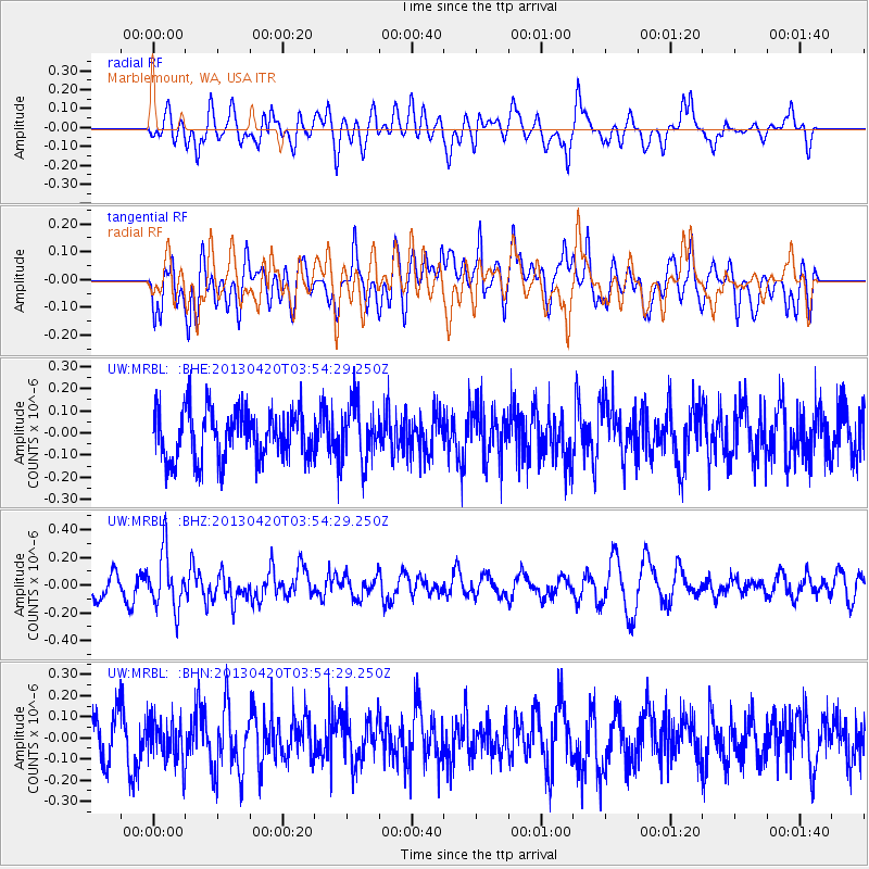
MRBL Marblemount, WA, USA - Earthquake Result Viewer
*The percent match for this event was below the threshold and hence no stack was calculated.
| Earthquake location: |
New Britain Region, P.N.G. |
| Earthquake latitude/longitude: |
-5.0/152.1 |
| Earthquake time(UTC): |
2013/04/20 (110) 03:42:02 GMT |
| Earthquake Depth: |
65 km |
| Earthquake Magnitude: |
5.6 MW, 5.6 MB, 5.7 MW |
| Earthquake Catalog/Contributor: |
NEIC PDE/NEIC PDE-W |
|
| Network: |
UW Pacific Northwest Regional Seismic Network |
| Station: |
MRBL Marblemount, WA, USA |
| Lat/Lon: |
48.52 N/121.48 W |
| Elevation: |
75 m |
|
| Distance: |
91.3 deg |
| Az: |
41.586 deg |
| Baz: |
264.014 deg |
| Ray Param: |
$rayparam |
*The percent match for this event was below the threshold and hence was not used in the summary stack. |
|
| Radial Match: |
49.939167 % |
| Radial Bump: |
400 |
| Transverse Match: |
54.898956 % |
| Transverse Bump: |
400 |
| SOD ConfigId: |
512894 |
| Insert Time: |
2013-09-13 13:54:45.091 +0000 |
| GWidth: |
2.5 |
| Max Bumps: |
400 |
| Tol: |
0.001 |
|
Signal To Noise
| Channel | StoN | STA | LTA |
| UW:MRBL: :BHZ:20130420T03:54:29.250Z | 2.425175 | 2.029482E-7 | 8.368394E-8 |
| UW:MRBL: :BHN:20130420T03:54:29.250Z | 1.02088 | 1.0676171E-7 | 1.0457812E-7 |
| UW:MRBL: :BHE:20130420T03:54:29.250Z | 1.1813935 | 1.3285936E-7 | 1.1245987E-7 |
| Arrivals |
| Ps | |
| PpPs | |
| PsPs/PpSs | |


