You are here: Home > Network List > TJ - Tajikistan National Seismic Network Stations List
> Station GARM Garm, Tajikistan > Earthquake Result Viewer
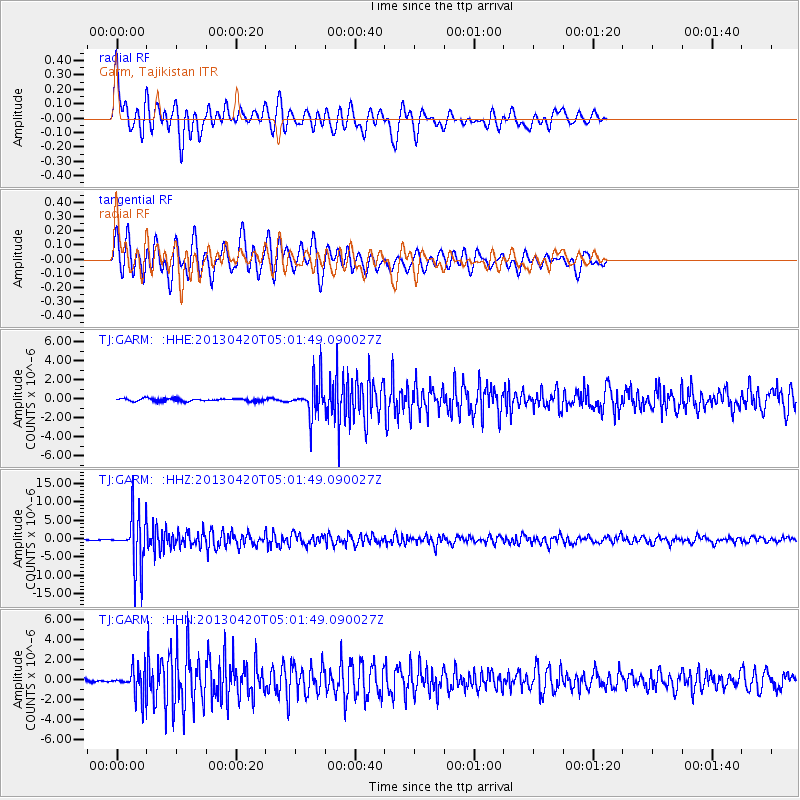
GARM Garm, Tajikistan - Earthquake Result Viewer
*The percent match for this event was below the threshold and hence no stack was calculated.
| Earthquake location: |
Banda Sea |
| Earthquake latitude/longitude: |
-6.3/130.2 |
| Earthquake time(UTC): |
2013/04/20 (110) 04:51:12 GMT |
| Earthquake Depth: |
108 km |
| Earthquake Magnitude: |
6.0 MW, 5.9 MW, 6.0 MB |
| Earthquake Catalog/Contributor: |
NEIC PDE/NEIC PDE-W |
|
| Network: |
TJ Tajikistan National Seismic Network |
| Station: |
GARM Garm, Tajikistan |
| Lat/Lon: |
39.00 N/70.32 E |
| Elevation: |
1305 m |
|
| Distance: |
71.3 deg |
| Az: |
314.634 deg |
| Baz: |
114.794 deg |
| Ray Param: |
$rayparam |
*The percent match for this event was below the threshold and hence was not used in the summary stack. |
|
| Radial Match: |
67.60628 % |
| Radial Bump: |
400 |
| Transverse Match: |
77.97025 % |
| Transverse Bump: |
400 |
| SOD ConfigId: |
512894 |
| Insert Time: |
2013-09-13 14:06:46.387 +0000 |
| GWidth: |
2.5 |
| Max Bumps: |
400 |
| Tol: |
0.001 |
|
Signal To Noise
| Channel | StoN | STA | LTA |
| TJ:GARM: :HHZ:20130420T05:01:49.090027Z | 48.15786 | 6.854433E-6 | 1.4233258E-7 |
| TJ:GARM: :HHN:20130420T05:01:49.090027Z | 12.520687 | 1.3147459E-6 | 1.0500589E-7 |
| TJ:GARM: :HHE:20130420T05:01:49.090027Z | 13.296525 | 1.8739631E-6 | 1.4093631E-7 |
| Arrivals |
| Ps | |
| PpPs | |
| PsPs/PpSs | |


