You are here: Home > Network List > AC - Albanian Seismological Network Stations List
> Station TPE Tepelene, Albania > Earthquake Result Viewer
TPE Tepelene, Albania - Earthquake Result Viewer
| Earthquake location: |
Kuril Islands |
| Earthquake latitude/longitude: |
50.1/157.1 |
| Earthquake time(UTC): |
2013/04/20 (110) 13:12:50 GMT |
| Earthquake Depth: |
18 km |
| Earthquake Magnitude: |
6.1 MW, 5.8 MB, 5.9 MS, 6.0 MW |
| Earthquake Catalog/Contributor: |
NEIC PDE/NEIC PDE-W |
|
| Network: |
AC Albanian Seismological Network |
| Station: |
TPE Tepelene, Albania |
| Lat/Lon: |
40.29 N/20.01 E |
| Elevation: |
273 m |
|
| Distance: |
82.4 deg |
| Az: |
328.341 deg |
| Baz: |
26.226 deg |
| Ray Param: |
0.046879902 |
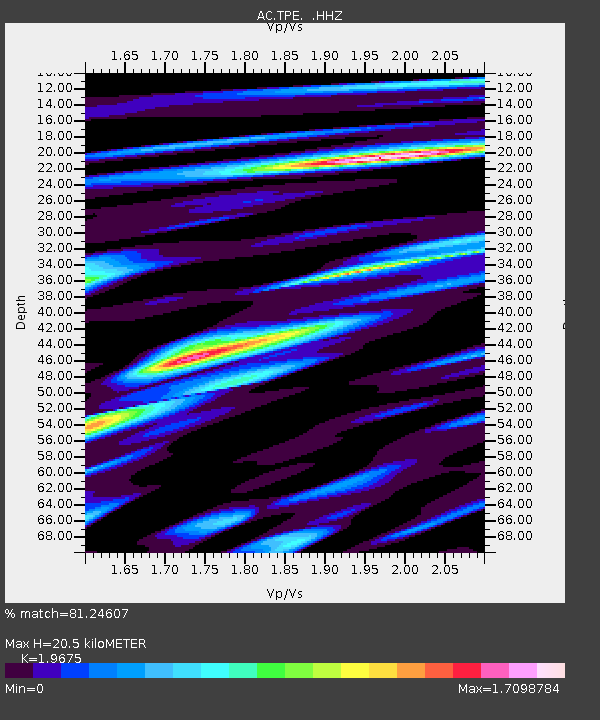
| Estimated Moho Depth: |
20.5 km |
| Estimated Crust Vp/Vs: |
1.97 |
| Assumed Crust Vp: |
6.291 km/s |
| Estimated Crust Vs: |
3.198 km/s |
| Estimated Crust Poisson's Ratio: |
0.33 |
|
| Radial Match: |
81.24607 % |
| Radial Bump: |
400 |
| Transverse Match: |
76.22828 % |
| Transverse Bump: |
400 |
| SOD ConfigId: |
512894 |
| Insert Time: |
2013-09-13 14:14:54.195 +0000 |
| GWidth: |
2.5 |
| Max Bumps: |
400 |
| Tol: |
0.001 |
|

Signal To Noise
| Channel | StoN | STA | LTA |
| AC:TPE: :HHZ:20130420T13:24:40.132009Z | 21.61118 | 1.765013E-6 | 8.16713E-8 |
| AC:TPE: :HHN:20130420T13:24:40.132009Z | 6.561383 | 7.724258E-7 | 1.1772302E-7 |
| AC:TPE: :HHE:20130420T13:24:40.132009Z | 3.164904 | 4.5600066E-7 | 1.440804E-7 |
| Arrivals |
| Ps | 3.2 SECOND |
| PpPs | 9.5 SECOND |
| PsPs/PpSs | 13 SECOND |


