You are here: Home > Network List > AK - Alaska Regional Network Stations List
> Station KIAG Kiagna River, AK, USA > Earthquake Result Viewer
KIAG Kiagna River, AK, USA - Earthquake Result Viewer
| Earthquake location: |
Kuril Islands |
| Earthquake latitude/longitude: |
50.1/157.1 |
| Earthquake time(UTC): |
2013/04/20 (110) 13:12:50 GMT |
| Earthquake Depth: |
18 km |
| Earthquake Magnitude: |
6.1 MW, 5.8 MB, 5.9 MS, 6.0 MW |
| Earthquake Catalog/Contributor: |
NEIC PDE/NEIC PDE-W |
|
| Network: |
AK Alaska Regional Network |
| Station: |
KIAG Kiagna River, AK, USA |
| Lat/Lon: |
60.92 N/142.36 W |
| Elevation: |
1773 m |
|
| Distance: |
34.7 deg |
| Az: |
48.367 deg |
| Baz: |
279.811 deg |
| Ray Param: |
0.07760552 |
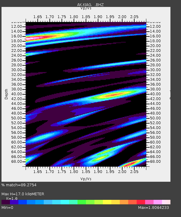
| Estimated Moho Depth: |
17.0 km |
| Estimated Crust Vp/Vs: |
1.60 |
| Assumed Crust Vp: |
6.566 km/s |
| Estimated Crust Vs: |
4.104 km/s |
| Estimated Crust Poisson's Ratio: |
0.18 |
|
| Radial Match: |
89.2754 % |
| Radial Bump: |
400 |
| Transverse Match: |
75.66965 % |
| Transverse Bump: |
400 |
| SOD ConfigId: |
512894 |
| Insert Time: |
2013-09-13 14:16:41.716 +0000 |
| GWidth: |
2.5 |
| Max Bumps: |
400 |
| Tol: |
0.001 |
|

Signal To Noise
| Channel | StoN | STA | LTA |
| AK:KIAG: :BHZ:20130420T13:19:08.16799Z | 4.435858 | 3.107352E-7 | 7.005076E-8 |
| AK:KIAG: :BHN:20130420T13:19:08.16799Z | 1.4635149 | 9.5567145E-8 | 6.5299744E-8 |
| AK:KIAG: :BHE:20130420T13:19:08.16799Z | 3.9087098 | 2.5387405E-7 | 6.4950854E-8 |
| Arrivals |
| Ps | 1.7 SECOND |
| PpPs | 6.2 SECOND |
| PsPs/PpSs | 7.9 SECOND |


