You are here: Home > Network List > PS - Pacific21 Stations List
> Station PATS 6onpei, Micronesia > Earthquake Result Viewer
PATS 6onpei, Micronesia - Earthquake Result Viewer
| Earthquake location: |
South Of Fiji Islands |
| Earthquake latitude/longitude: |
-26.0/-177.5 |
| Earthquake time(UTC): |
2007/12/09 (343) 07:28:20 GMT |
| Earthquake Depth: |
152 km |
| Earthquake Magnitude: |
7.0 MB, 7.8 MW, 7.7 MW |
| Earthquake Catalog/Contributor: |
WHDF/NEIC |
|
| Network: |
PS Pacific21 |
| Station: |
PATS 6onpei, Micronesia |
| Lat/Lon: |
6.84 N/158.32 E |
| Elevation: |
10 m |
|
| Distance: |
40.2 deg |
| Az: |
320.959 deg |
| Baz: |
145.188 deg |
| Ray Param: |
0.0739816 |
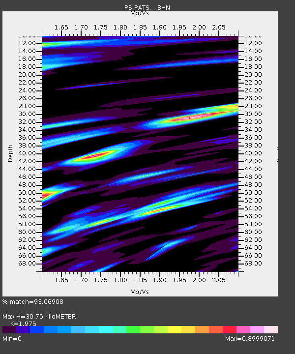
| Estimated Moho Depth: |
30.75 km |
| Estimated Crust Vp/Vs: |
1.98 |
| Assumed Crust Vp: |
4.24 km/s |
| Estimated Crust Vs: |
2.147 km/s |
| Estimated Crust Poisson's Ratio: |
0.33 |
|
| Radial Match: |
93.06908 % |
| Radial Bump: |
354 |
| Transverse Match: |
83.52465 % |
| Transverse Bump: |
400 |
| SOD ConfigId: |
2564 |
| Insert Time: |
2010-02-27 03:13:17.220 +0000 |
| GWidth: |
2.5 |
| Max Bumps: |
400 |
| Tol: |
0.001 |
|

Signal To Noise
| Channel | StoN | STA | LTA |
| PS:PATS: :BHN:20071209T07:35:11.911003Z | 2.8432293 | 4.343977E-6 | 1.527832E-6 |
| PS:PATS: :BHE:20071209T07:35:11.911003Z | 1.7025348 | 2.8509382E-6 | 1.6745256E-6 |
| PS:PATS: :BHZ:20071209T07:35:11.911003Z | 4.515697 | 9.896404E-6 | 2.1915562E-6 |
| Arrivals |
| Ps | 7.3 SECOND |
| PpPs | 21 SECOND |
| PsPs/PpSs | 28 SECOND |


