You are here: Home > Network List > PS - Pacific21 Stations List
> Station PATS 6onpei, Micronesia > Earthquake Result Viewer
PATS 6onpei, Micronesia - Earthquake Result Viewer

| Earthquake location: |
South Of Fiji Islands |
| Earthquake latitude/longitude: |
-25.8/179.5 |
| Earthquake time(UTC): |
2007/10/16 (289) 21:05:43 GMT |
| Earthquake Depth: |
509 km |
| Earthquake Magnitude: |
6.2 MB, 6.6 MW, 6.5 MW |
| Earthquake Catalog/Contributor: |
WHDF/NEIC |
|
| Network: |
PS Pacific21 |
| Station: |
PATS 6onpei, Micronesia |
| Lat/Lon: |
6.84 N/158.32 E |
| Elevation: |
10 m |
|
| Distance: |
38.4 deg |
| Az: |
324.671 deg |
| Baz: |
148.327 deg |
| Ray Param: |
0.07311476 |
| Estimated Moho Depth: |
11.25 km |
| Estimated Crust Vp/Vs: |
1.73 |
| Assumed Crust Vp: |
4.24 km/s |
| Estimated Crust Vs: |
2.447 km/s |
| Estimated Crust Poisson's Ratio: |
0.25 |
|
| Radial Match: |
80.73676 % |
| Radial Bump: |
232 |
| Transverse Match: |
77.76492 % |
| Transverse Bump: |
327 |
| SOD ConfigId: |
2564 |
| Insert Time: |
2010-02-27 03:13:18.365 +0000 |
| GWidth: |
2.5 |
| Max Bumps: |
400 |
| Tol: |
0.001 |
|
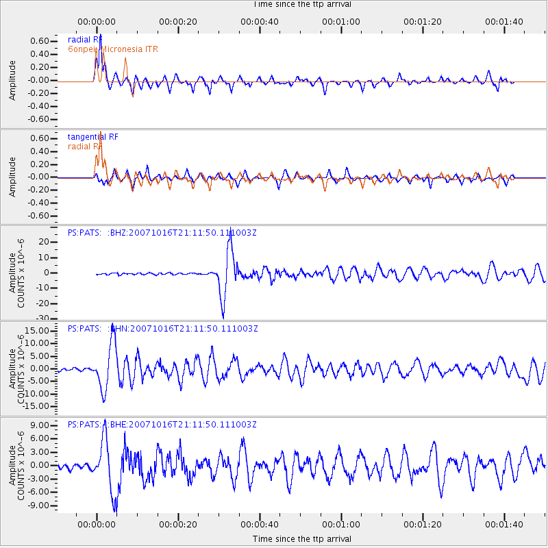
Signal To Noise
| Channel | StoN | STA | LTA |
| PS:PATS: :BHN:20071016T21:11:50.111003Z | 17.447758 | 9.3389735E-6 | 5.3525355E-7 |
| PS:PATS: :BHE:20071016T21:11:50.111003Z | 11.806611 | 5.9916274E-6 | 5.074807E-7 |
| PS:PATS: :BHZ:20071016T21:11:50.111003Z | 31.65287 | 1.5443451E-5 | 4.8790054E-7 |
| Arrivals |
| Ps | 2.0 SECOND |
| PpPs | 7.0 SECOND |
| PsPs/PpSs | 9.0 SECOND |


