You are here: Home > Network List > CN - Canadian National Seismograph Network Stations List
> Station ATKO ATIKOKAN IRON MINE, ON > Earthquake Result Viewer
ATKO ATIKOKAN IRON MINE, ON - Earthquake Result Viewer
| Earthquake location: |
Kuril Islands |
| Earthquake latitude/longitude: |
50.1/157.1 |
| Earthquake time(UTC): |
2013/04/20 (110) 13:12:50 GMT |
| Earthquake Depth: |
18 km |
| Earthquake Magnitude: |
6.1 MW, 5.8 MB, 5.9 MS, 6.0 MW |
| Earthquake Catalog/Contributor: |
NEIC PDE/NEIC PDE-W |
|
| Network: |
CN Canadian National Seismograph Network |
| Station: |
ATKO ATIKOKAN IRON MINE, ON |
| Lat/Lon: |
48.82 N/91.60 W |
| Elevation: |
383 m |
|
| Distance: |
65.2 deg |
| Az: |
42.74 deg |
| Baz: |
318.599 deg |
| Ray Param: |
0.058428526 |
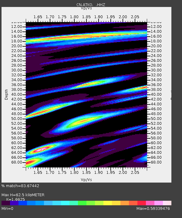
| Estimated Moho Depth: |
62.5 km |
| Estimated Crust Vp/Vs: |
1.66 |
| Assumed Crust Vp: |
6.467 km/s |
| Estimated Crust Vs: |
3.89 km/s |
| Estimated Crust Poisson's Ratio: |
0.22 |
|
| Radial Match: |
83.67442 % |
| Radial Bump: |
327 |
| Transverse Match: |
55.22276 % |
| Transverse Bump: |
400 |
| SOD ConfigId: |
512894 |
| Insert Time: |
2013-09-13 14:23:56.271 +0000 |
| GWidth: |
2.5 |
| Max Bumps: |
400 |
| Tol: |
0.001 |
|

Signal To Noise
| Channel | StoN | STA | LTA |
| CN:ATKO: :HHZ:20130420T13:22:59.319998Z | 5.7453117 | 2.0466014E-7 | 3.562211E-8 |
| CN:ATKO: :HHN:20130420T13:22:59.319998Z | 2.4313188 | 7.8656925E-8 | 3.2351547E-8 |
| CN:ATKO: :HHE:20130420T13:22:59.319998Z | 2.2475584 | 6.801675E-8 | 3.0262505E-8 |
| Arrivals |
| Ps | 6.7 SECOND |
| PpPs | 25 SECOND |
| PsPs/PpSs | 31 SECOND |


