You are here: Home > Network List > GO - National Seismic Network of Georgia Stations List
> Station ONI Oni, Georgia > Earthquake Result Viewer
ONI Oni, Georgia - Earthquake Result Viewer

| Earthquake location: |
Kuril Islands |
| Earthquake latitude/longitude: |
50.1/157.1 |
| Earthquake time(UTC): |
2013/04/20 (110) 13:12:50 GMT |
| Earthquake Depth: |
18 km |
| Earthquake Magnitude: |
6.1 MW, 5.8 MB, 5.9 MS, 6.0 MW |
| Earthquake Catalog/Contributor: |
NEIC PDE/NEIC PDE-W |
|
| Network: |
GO National Seismic Network of Georgia |
| Station: |
ONI Oni, Georgia |
| Lat/Lon: |
42.59 N/43.45 E |
| Elevation: |
0.0 m |
|
| Distance: |
71.1 deg |
| Az: |
314.36 deg |
| Baz: |
38.572 deg |
| Ray Param: |
0.054560483 |
| Estimated Moho Depth: |
29.25 km |
| Estimated Crust Vp/Vs: |
1.83 |
| Assumed Crust Vp: |
6.247 km/s |
| Estimated Crust Vs: |
3.423 km/s |
| Estimated Crust Poisson's Ratio: |
0.29 |
|
| Radial Match: |
84.33329 % |
| Radial Bump: |
340 |
| Transverse Match: |
83.63735 % |
| Transverse Bump: |
400 |
| SOD ConfigId: |
512894 |
| Insert Time: |
2013-09-13 14:28:41.313 +0000 |
| GWidth: |
2.5 |
| Max Bumps: |
400 |
| Tol: |
0.001 |
|
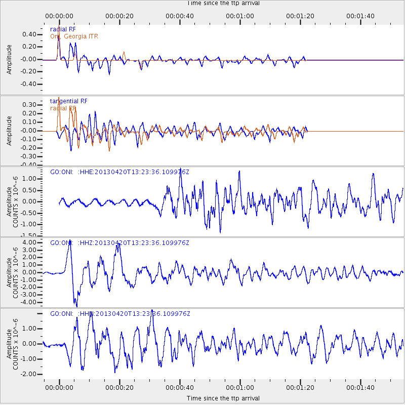
Signal To Noise
| Channel | StoN | STA | LTA |
| GO:ONI: :HHZ:20130420T13:23:36.109976Z | 23.225212 | 1.9552042E-6 | 8.4184556E-8 |
| GO:ONI: :HHN:20130420T13:23:36.109976Z | 3.9239204 | 5.524077E-7 | 1.4077953E-7 |
| GO:ONI: :HHE:20130420T13:23:36.109976Z | 2.5013835 | 2.449317E-7 | 9.791849E-8 |
| Arrivals |
| Ps | 4.0 SECOND |
| PpPs | 13 SECOND |
| PsPs/PpSs | 17 SECOND |


