You are here: Home > Network List > IC - New China Digital Seismograph Network Stations List
> Station QIZ Qiongzhong, Hainan Province, China > Earthquake Result Viewer
QIZ Qiongzhong, Hainan Province, China - Earthquake Result Viewer

| Earthquake location: |
Kuril Islands |
| Earthquake latitude/longitude: |
50.1/157.1 |
| Earthquake time(UTC): |
2013/04/20 (110) 13:12:50 GMT |
| Earthquake Depth: |
18 km |
| Earthquake Magnitude: |
6.1 MW, 5.8 MB, 5.9 MS, 6.0 MW |
| Earthquake Catalog/Contributor: |
NEIC PDE/NEIC PDE-W |
|
| Network: |
IC New China Digital Seismograph Network |
| Station: |
QIZ Qiongzhong, Hainan Province, China |
| Lat/Lon: |
19.03 N/109.84 E |
| Elevation: |
240 m |
|
| Distance: |
48.6 deg |
| Az: |
247.919 deg |
| Baz: |
39.11 deg |
| Ray Param: |
0.069220625 |
| Estimated Moho Depth: |
34.25 km |
| Estimated Crust Vp/Vs: |
1.68 |
| Assumed Crust Vp: |
6.182 km/s |
| Estimated Crust Vs: |
3.68 km/s |
| Estimated Crust Poisson's Ratio: |
0.23 |
|
| Radial Match: |
96.52098 % |
| Radial Bump: |
400 |
| Transverse Match: |
89.04748 % |
| Transverse Bump: |
400 |
| SOD ConfigId: |
512894 |
| Insert Time: |
2013-09-13 14:30:21.178 +0000 |
| GWidth: |
2.5 |
| Max Bumps: |
400 |
| Tol: |
0.001 |
|
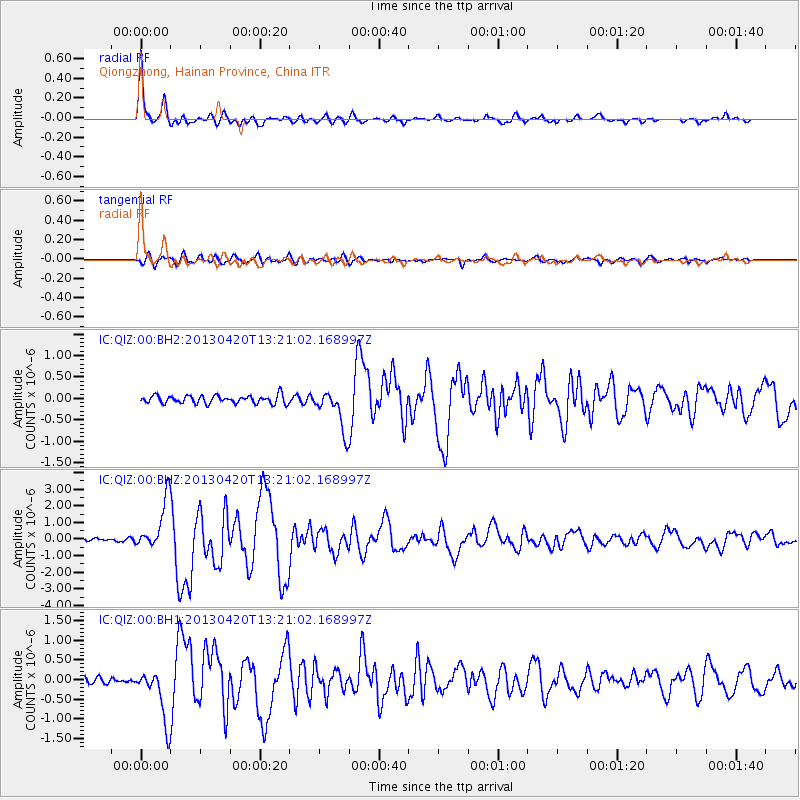
Signal To Noise
| Channel | StoN | STA | LTA |
| IC:QIZ:00:BHZ:20130420T13:21:02.168997Z | 14.245968 | 1.4804165E-6 | 1.0391828E-7 |
| IC:QIZ:00:BH1:20130420T13:21:02.168997Z | 11.181832 | 6.75286E-7 | 6.039135E-8 |
| IC:QIZ:00:BH2:20130420T13:21:02.168997Z | 5.07237 | 4.7224074E-7 | 9.310061E-8 |
| Arrivals |
| Ps | 4.0 SECOND |
| PpPs | 14 SECOND |
| PsPs/PpSs | 18 SECOND |


