You are here: Home > Network List > PS - Pacific21 Stations List
> Station PATS 6onpei, Micronesia > Earthquake Result Viewer
PATS 6onpei, Micronesia - Earthquake Result Viewer

| Earthquake location: |
Northern Sumatra, Indonesia |
| Earthquake latitude/longitude: |
3.4/99.1 |
| Earthquake time(UTC): |
2006/12/01 (335) 03:58:21 GMT |
| Earthquake Depth: |
206 km |
| Earthquake Magnitude: |
6.0 MB, 6.3 MW, 6.3 MW |
| Earthquake Catalog/Contributor: |
WHDF/NEIC |
|
| Network: |
PS Pacific21 |
| Station: |
PATS 6onpei, Micronesia |
| Lat/Lon: |
6.84 N/158.32 E |
| Elevation: |
10 m |
|
| Distance: |
59.1 deg |
| Az: |
84.101 deg |
| Baz: |
269.87 deg |
| Ray Param: |
0.061764397 |
| Estimated Moho Depth: |
15.5 km |
| Estimated Crust Vp/Vs: |
2.08 |
| Assumed Crust Vp: |
4.24 km/s |
| Estimated Crust Vs: |
2.036 km/s |
| Estimated Crust Poisson's Ratio: |
0.35 |
|
| Radial Match: |
80.87058 % |
| Radial Bump: |
400 |
| Transverse Match: |
58.104202 % |
| Transverse Bump: |
400 |
| SOD ConfigId: |
2564 |
| Insert Time: |
2010-02-27 03:13:40.417 +0000 |
| GWidth: |
2.5 |
| Max Bumps: |
400 |
| Tol: |
0.001 |
|
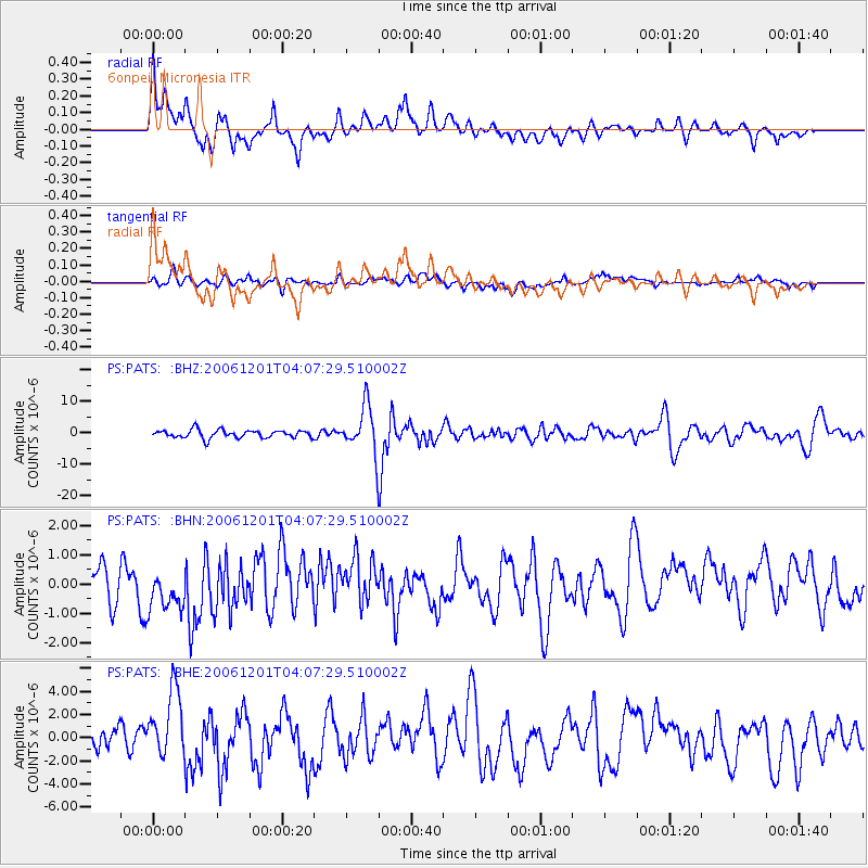
Signal To Noise
| Channel | StoN | STA | LTA |
| PS:PATS: :BHN:20061201T04:07:29.510002Z | 1.9696116 | 9.441178E-7 | 4.793421E-7 |
| PS:PATS: :BHE:20061201T04:07:29.510002Z | 2.9552727 | 2.8465868E-6 | 9.632231E-7 |
| PS:PATS: :BHZ:20061201T04:07:29.510002Z | 5.8575025 | 7.3207816E-6 | 1.2498127E-6 |
| Arrivals |
| Ps | 4.0 SECOND |
| PpPs | 11 SECOND |
| PsPs/PpSs | 15 SECOND |


