You are here: Home > Network List > KR - Kyrgyz Digital Network Stations List
> Station BOOM Boom, Kyrgyzstan > Earthquake Result Viewer
BOOM Boom, Kyrgyzstan - Earthquake Result Viewer
| Earthquake location: |
Kuril Islands |
| Earthquake latitude/longitude: |
50.1/157.1 |
| Earthquake time(UTC): |
2013/04/20 (110) 13:12:50 GMT |
| Earthquake Depth: |
18 km |
| Earthquake Magnitude: |
6.1 MW, 5.8 MB, 5.9 MS, 6.0 MW |
| Earthquake Catalog/Contributor: |
NEIC PDE/NEIC PDE-W |
|
| Network: |
KR Kyrgyz Digital Network |
| Station: |
BOOM Boom, Kyrgyzstan |
| Lat/Lon: |
42.49 N/75.94 E |
| Elevation: |
1737 m |
|
| Distance: |
54.0 deg |
| Az: |
295.389 deg |
| Baz: |
51.867 deg |
| Ray Param: |
0.06569743 |
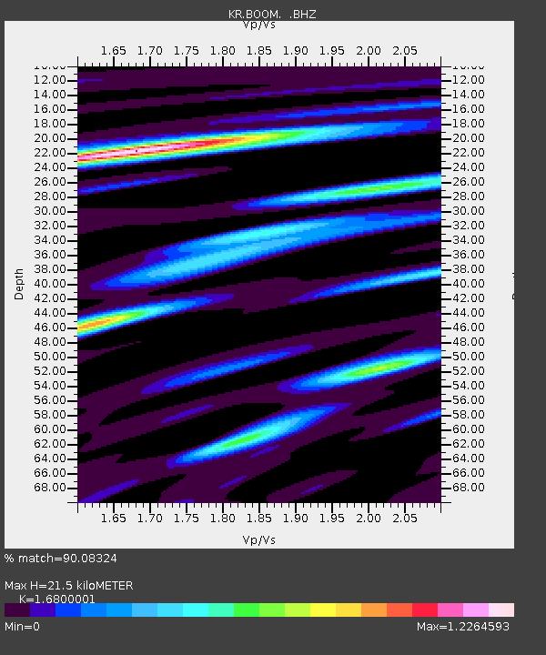
| Estimated Moho Depth: |
21.5 km |
| Estimated Crust Vp/Vs: |
1.68 |
| Assumed Crust Vp: |
6.306 km/s |
| Estimated Crust Vs: |
3.754 km/s |
| Estimated Crust Poisson's Ratio: |
0.23 |
|
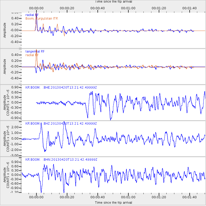
| Radial Match: |
90.08324 % |
| Radial Bump: |
400 |
| Transverse Match: |
87.85048 % |
| Transverse Bump: |
400 |
| SOD ConfigId: |
512894 |
| Insert Time: |
2013-09-13 14:34:37.863 +0000 |
| GWidth: |
2.5 |
| Max Bumps: |
400 |
| Tol: |
0.001 |
|
Signal To Noise
| Channel | StoN | STA | LTA |
| KR:BOOM: :BHZ:20130420T13:21:42.49999Z | 15.406791 | 1.1556516E-6 | 7.500923E-8 |
| KR:BOOM: :BHN:20130420T13:21:42.49999Z | 7.8123465 | 4.741255E-7 | 6.068925E-8 |
| KR:BOOM: :BHE:20130420T13:21:42.49999Z | 6.7388725 | 3.3995684E-7 | 5.0447138E-8 |
| Arrivals |
| Ps | 2.4 SECOND |
| PpPs | 8.7 SECOND |
| PsPs/PpSs | 11 SECOND |


