You are here: Home > Network List > MN - MEDNET Project Stations List
> Station PDG Podgorica, Crna Gora > Earthquake Result Viewer
PDG Podgorica, Crna Gora - Earthquake Result Viewer
| Earthquake location: |
Kuril Islands |
| Earthquake latitude/longitude: |
50.1/157.1 |
| Earthquake time(UTC): |
2013/04/20 (110) 13:12:50 GMT |
| Earthquake Depth: |
18 km |
| Earthquake Magnitude: |
6.1 MW, 5.8 MB, 5.9 MS, 6.0 MW |
| Earthquake Catalog/Contributor: |
NEIC PDE/NEIC PDE-W |
|
| Network: |
MN MEDNET Project |
| Station: |
PDG Podgorica, Crna Gora |
| Lat/Lon: |
42.43 N/19.26 E |
| Elevation: |
40 m |
|
| Distance: |
80.8 deg |
| Az: |
329.801 deg |
| Baz: |
25.947 deg |
| Ray Param: |
0.048043925 |
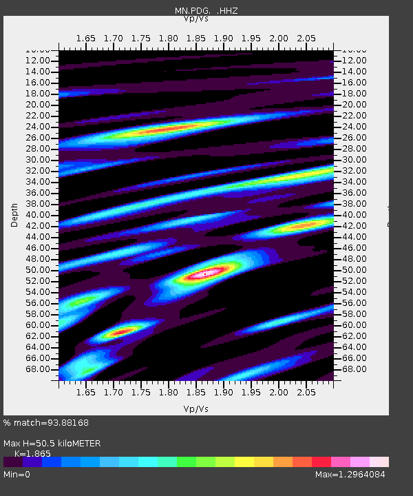
| Estimated Moho Depth: |
50.5 km |
| Estimated Crust Vp/Vs: |
1.87 |
| Assumed Crust Vp: |
6.291 km/s |
| Estimated Crust Vs: |
3.373 km/s |
| Estimated Crust Poisson's Ratio: |
0.30 |
|
| Radial Match: |
93.88168 % |
| Radial Bump: |
376 |
| Transverse Match: |
85.71461 % |
| Transverse Bump: |
400 |
| SOD ConfigId: |
512894 |
| Insert Time: |
2013-09-13 14:36:54.057 +0000 |
| GWidth: |
2.5 |
| Max Bumps: |
400 |
| Tol: |
0.001 |
|

Signal To Noise
| Channel | StoN | STA | LTA |
| MN:PDG: :HHZ:20130420T13:24:31.353994Z | 19.646332 | 1.6505783E-6 | 8.401457E-8 |
| MN:PDG: :HHN:20130420T13:24:31.353994Z | 8.08119 | 5.2947115E-7 | 6.551896E-8 |
| MN:PDG: :HHE:20130420T13:24:31.353994Z | 4.483149 | 2.541353E-7 | 5.6686787E-8 |
| Arrivals |
| Ps | 7.1 SECOND |
| PpPs | 22 SECOND |
| PsPs/PpSs | 30 SECOND |


