You are here: Home > Network List > PE - Penn State Network Stations List
> Station PAGS PA Geological Survey > Earthquake Result Viewer
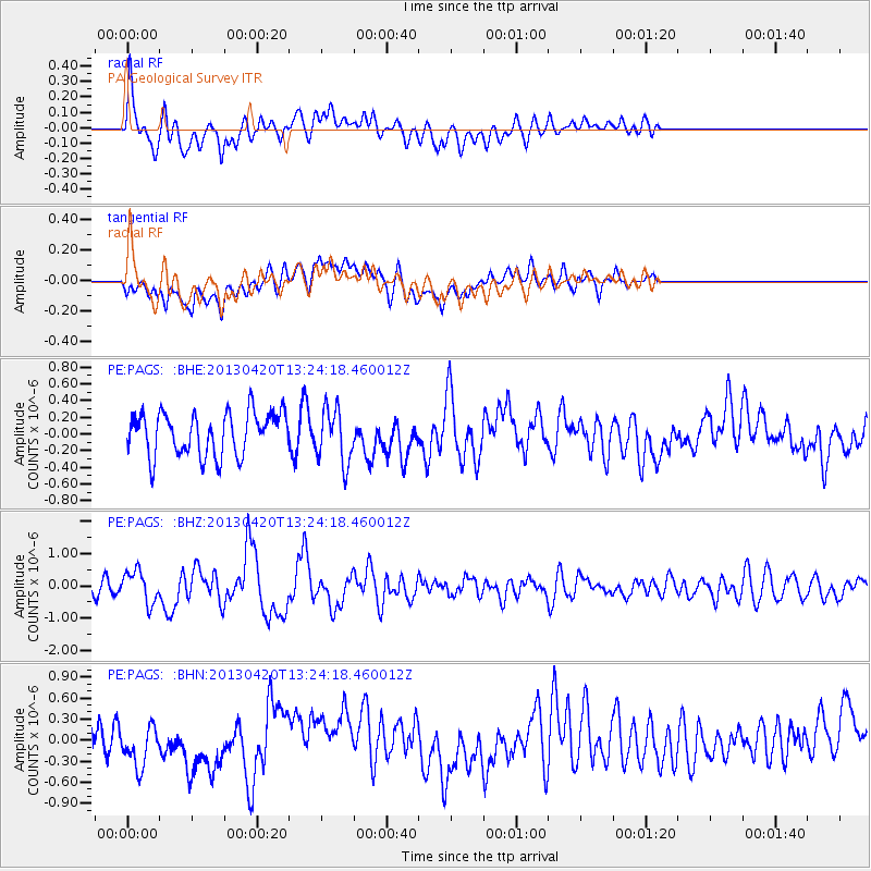
PAGS PA Geological Survey - Earthquake Result Viewer
*The percent match for this event was below the threshold and hence no stack was calculated.
| Earthquake location: |
Kuril Islands |
| Earthquake latitude/longitude: |
50.1/157.1 |
| Earthquake time(UTC): |
2013/04/20 (110) 13:12:50 GMT |
| Earthquake Depth: |
18 km |
| Earthquake Magnitude: |
6.1 MW, 5.8 MB, 5.9 MS, 6.0 MW |
| Earthquake Catalog/Contributor: |
NEIC PDE/NEIC PDE-W |
|
| Network: |
PE Penn State Network |
| Station: |
PAGS PA Geological Survey |
| Lat/Lon: |
40.23 N/76.72 W |
| Elevation: |
120 m |
|
| Distance: |
78.4 deg |
| Az: |
39.147 deg |
| Baz: |
327.925 deg |
| Ray Param: |
$rayparam |
*The percent match for this event was below the threshold and hence was not used in the summary stack. |
|
| Radial Match: |
55.28585 % |
| Radial Bump: |
400 |
| Transverse Match: |
44.48157 % |
| Transverse Bump: |
400 |
| SOD ConfigId: |
512894 |
| Insert Time: |
2013-09-13 14:41:22.226 +0000 |
| GWidth: |
2.5 |
| Max Bumps: |
400 |
| Tol: |
0.001 |
|
Signal To Noise
| Channel | StoN | STA | LTA |
| PE:PAGS: :BHZ:20130420T13:24:18.460012Z | 2.4209056 | 4.936641E-7 | 2.0391714E-7 |
| PE:PAGS: :BHN:20130420T13:24:18.460012Z | 1.9242464 | 3.5821867E-7 | 1.8616049E-7 |
| PE:PAGS: :BHE:20130420T13:24:18.460012Z | 1.2803209 | 3.2785016E-7 | 2.5606874E-7 |
| Arrivals |
| Ps | |
| PpPs | |
| PsPs/PpSs | |


