You are here: Home > Network List > TA - USArray Transportable Network (new EarthScope stations) Stations List
> Station F38A Pierce - Schroeder Farm, Trego, WI, USA > Earthquake Result Viewer
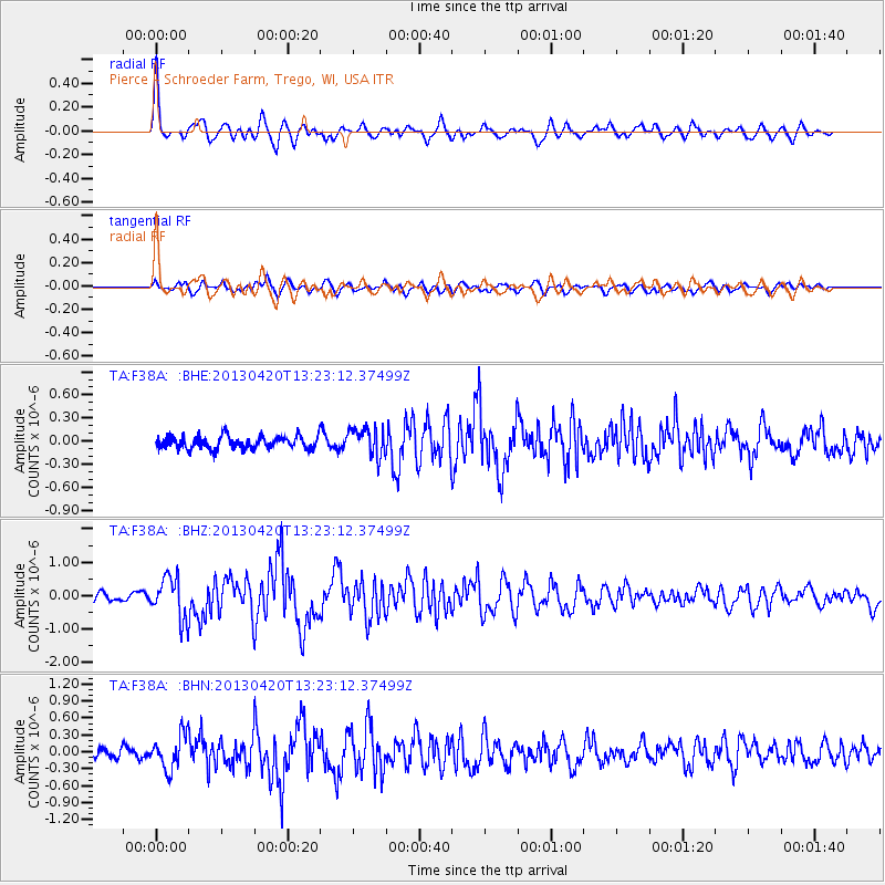
F38A Pierce - Schroeder Farm, Trego, WI, USA - Earthquake Result Viewer
| Earthquake location: |
Kuril Islands |
| Earthquake latitude/longitude: |
50.1/157.1 |
| Earthquake time(UTC): |
2013/04/20 (110) 13:12:50 GMT |
| Earthquake Depth: |
18 km |
| Earthquake Magnitude: |
6.1 MW, 5.8 MB, 5.9 MS, 6.0 MW |
| Earthquake Catalog/Contributor: |
NEIC PDE/NEIC PDE-W |
|
| Network: |
TA USArray Transportable Network (new EarthScope stations) |
| Station: |
F38A Pierce - Schroeder Farm, Trego, WI, USA |
| Lat/Lon: |
45.96 N/91.88 W |
| Elevation: |
321 m |
|
| Distance: |
67.2 deg |
| Az: |
44.952 deg |
| Baz: |
319.289 deg |
| Ray Param: |
0.057087805 |
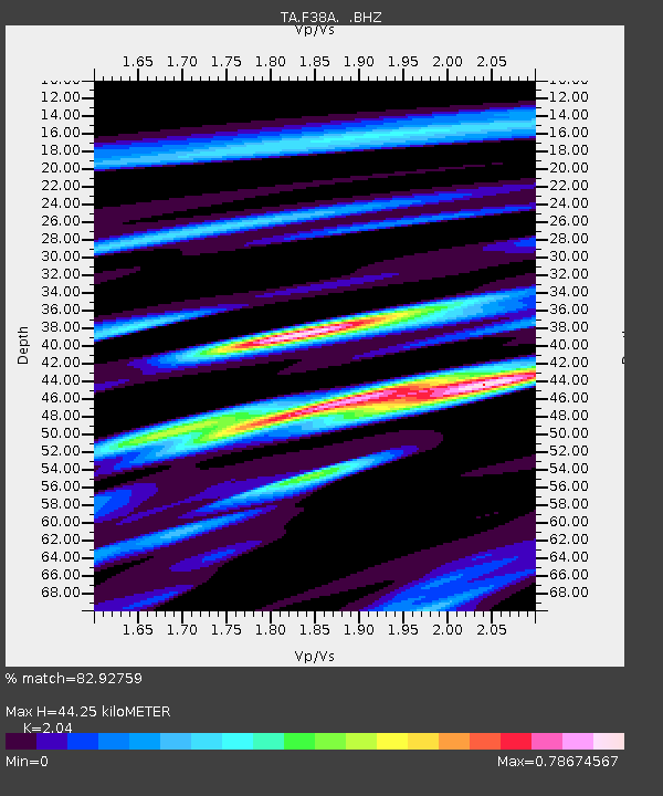
| Estimated Moho Depth: |
44.25 km |
| Estimated Crust Vp/Vs: |
2.04 |
| Assumed Crust Vp: |
6.571 km/s |
| Estimated Crust Vs: |
3.221 km/s |
| Estimated Crust Poisson's Ratio: |
0.34 |
|
| Radial Match: |
82.92759 % |
| Radial Bump: |
400 |
| Transverse Match: |
48.781395 % |
| Transverse Bump: |
400 |
| SOD ConfigId: |
512894 |
| Insert Time: |
2013-09-13 14:50:45.394 +0000 |
| GWidth: |
2.5 |
| Max Bumps: |
400 |
| Tol: |
0.001 |
|
Signal To Noise
| Channel | StoN | STA | LTA |
| TA:F38A: :BHZ:20130420T13:23:12.37499Z | 4.093833 | 6.127091E-7 | 1.4966636E-7 |
| TA:F38A: :BHN:20130420T13:23:12.37499Z | 1.7880913 | 3.0166024E-7 | 1.6870516E-7 |
| TA:F38A: :BHE:20130420T13:23:12.37499Z | 2.3097231 | 1.8843639E-7 | 8.158397E-8 |
| Arrivals |
| Ps | 7.3 SECOND |
| PpPs | 20 SECOND |
| PsPs/PpSs | 27 SECOND |


