You are here: Home > Network List > TA - USArray Transportable Network (new EarthScope stations) Stations List
> Station G41A Antigo, WI, USA > Earthquake Result Viewer
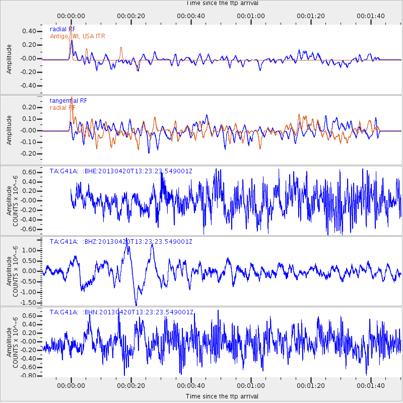
G41A Antigo, WI, USA - Earthquake Result Viewer
*The percent match for this event was below the threshold and hence no stack was calculated.
| Earthquake location: |
Kuril Islands |
| Earthquake latitude/longitude: |
50.1/157.1 |
| Earthquake time(UTC): |
2013/04/20 (110) 13:12:50 GMT |
| Earthquake Depth: |
18 km |
| Earthquake Magnitude: |
6.1 MW, 5.8 MB, 5.9 MS, 6.0 MW |
| Earthquake Catalog/Contributor: |
NEIC PDE/NEIC PDE-W |
|
| Network: |
TA USArray Transportable Network (new EarthScope stations) |
| Station: |
G41A Antigo, WI, USA |
| Lat/Lon: |
45.21 N/89.18 W |
| Elevation: |
464 m |
|
| Distance: |
69.0 deg |
| Az: |
43.905 deg |
| Baz: |
320.818 deg |
| Ray Param: |
$rayparam |
*The percent match for this event was below the threshold and hence was not used in the summary stack. |
|
| Radial Match: |
75.563446 % |
| Radial Bump: |
400 |
| Transverse Match: |
49.10201 % |
| Transverse Bump: |
400 |
| SOD ConfigId: |
512894 |
| Insert Time: |
2013-09-13 14:51:49.977 +0000 |
| GWidth: |
2.5 |
| Max Bumps: |
400 |
| Tol: |
0.001 |
|
Signal To Noise
| Channel | StoN | STA | LTA |
| TA:G41A: :BHZ:20130420T13:23:23.549001Z | 3.5202646 | 5.60868E-7 | 1.5932552E-7 |
| TA:G41A: :BHN:20130420T13:23:23.549001Z | 1.116009 | 1.5216744E-7 | 1.3634967E-7 |
| TA:G41A: :BHE:20130420T13:23:23.549001Z | 1.5347233 | 2.4861922E-7 | 1.6199613E-7 |
| Arrivals |
| Ps | |
| PpPs | |
| PsPs/PpSs | |


