You are here: Home > Network List > TA - USArray Transportable Network (new EarthScope stations) Stations List
> Station H41A Junction City, WI, USA > Earthquake Result Viewer
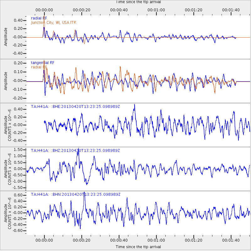
H41A Junction City, WI, USA - Earthquake Result Viewer
*The percent match for this event was below the threshold and hence no stack was calculated.
| Earthquake location: |
Kuril Islands |
| Earthquake latitude/longitude: |
50.1/157.1 |
| Earthquake time(UTC): |
2013/04/20 (110) 13:12:50 GMT |
| Earthquake Depth: |
18 km |
| Earthquake Magnitude: |
6.1 MW, 5.8 MB, 5.9 MS, 6.0 MW |
| Earthquake Catalog/Contributor: |
NEIC PDE/NEIC PDE-W |
|
| Network: |
TA USArray Transportable Network (new EarthScope stations) |
| Station: |
H41A Junction City, WI, USA |
| Lat/Lon: |
44.62 N/89.65 W |
| Elevation: |
348 m |
|
| Distance: |
69.2 deg |
| Az: |
44.586 deg |
| Baz: |
320.729 deg |
| Ray Param: |
$rayparam |
*The percent match for this event was below the threshold and hence was not used in the summary stack. |
|
| Radial Match: |
64.135124 % |
| Radial Bump: |
400 |
| Transverse Match: |
62.077934 % |
| Transverse Bump: |
400 |
| SOD ConfigId: |
512894 |
| Insert Time: |
2013-09-13 14:52:32.172 +0000 |
| GWidth: |
2.5 |
| Max Bumps: |
400 |
| Tol: |
0.001 |
|
Signal To Noise
| Channel | StoN | STA | LTA |
| TA:H41A: :BHZ:20130420T13:23:25.098989Z | 3.2454135 | 4.9645973E-7 | 1.5297272E-7 |
| TA:H41A: :BHN:20130420T13:23:25.098989Z | 1.5209563 | 1.4424306E-7 | 9.4837084E-8 |
| TA:H41A: :BHE:20130420T13:23:25.098989Z | 1.0930123 | 1.17139486E-7 | 1.0717124E-7 |
| Arrivals |
| Ps | |
| PpPs | |
| PsPs/PpSs | |


