You are here: Home > Network List > TA - USArray Transportable Network (new EarthScope stations) Stations List
> Station O49A Covington, OH, USA > Earthquake Result Viewer
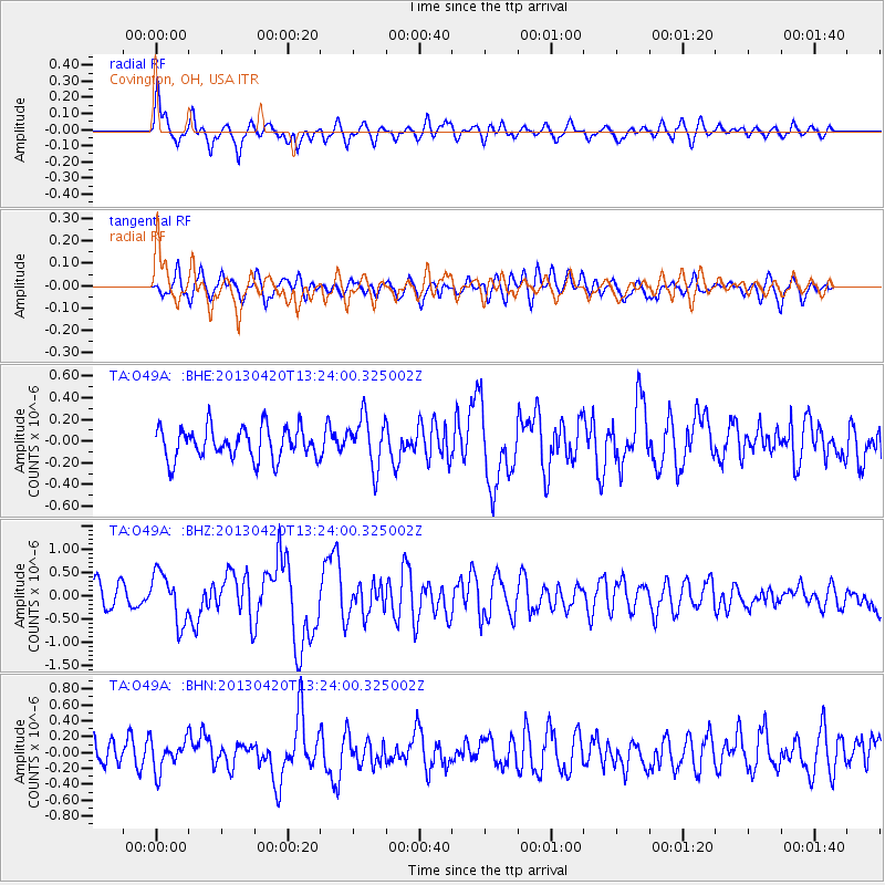
O49A Covington, OH, USA - Earthquake Result Viewer
*The percent match for this event was below the threshold and hence no stack was calculated.
| Earthquake location: |
Kuril Islands |
| Earthquake latitude/longitude: |
50.1/157.1 |
| Earthquake time(UTC): |
2013/04/20 (110) 13:12:50 GMT |
| Earthquake Depth: |
18 km |
| Earthquake Magnitude: |
6.1 MW, 5.8 MB, 5.9 MS, 6.0 MW |
| Earthquake Catalog/Contributor: |
NEIC PDE/NEIC PDE-W |
|
| Network: |
TA USArray Transportable Network (new EarthScope stations) |
| Station: |
O49A Covington, OH, USA |
| Lat/Lon: |
40.19 N/84.34 W |
| Elevation: |
292 m |
|
| Distance: |
75.2 deg |
| Az: |
44.136 deg |
| Baz: |
324.168 deg |
| Ray Param: |
$rayparam |
*The percent match for this event was below the threshold and hence was not used in the summary stack. |
|
| Radial Match: |
71.421 % |
| Radial Bump: |
400 |
| Transverse Match: |
54.47547 % |
| Transverse Bump: |
400 |
| SOD ConfigId: |
512894 |
| Insert Time: |
2013-09-13 14:59:44.711 +0000 |
| GWidth: |
2.5 |
| Max Bumps: |
400 |
| Tol: |
0.001 |
|
Signal To Noise
| Channel | StoN | STA | LTA |
| TA:O49A: :BHZ:20130420T13:24:00.325002Z | 2.2792358 | 5.28289E-7 | 2.3178337E-7 |
| TA:O49A: :BHN:20130420T13:24:00.325002Z | 1.0203171 | 1.9033902E-7 | 1.8654892E-7 |
| TA:O49A: :BHE:20130420T13:24:00.325002Z | 1.5813775 | 2.3161815E-7 | 1.4646608E-7 |
| Arrivals |
| Ps | |
| PpPs | |
| PsPs/PpSs | |


