You are here: Home > Network List > TA - USArray Transportable Network (new EarthScope stations) Stations List
> Station R45A Skylar, Fairfield, IL, USA > Earthquake Result Viewer
R45A Skylar, Fairfield, IL, USA - Earthquake Result Viewer
| Earthquake location: |
Kuril Islands |
| Earthquake latitude/longitude: |
50.1/157.1 |
| Earthquake time(UTC): |
2013/04/20 (110) 13:12:50 GMT |
| Earthquake Depth: |
18 km |
| Earthquake Magnitude: |
6.1 MW, 5.8 MB, 5.9 MS, 6.0 MW |
| Earthquake Catalog/Contributor: |
NEIC PDE/NEIC PDE-W |
|
| Network: |
TA USArray Transportable Network (new EarthScope stations) |
| Station: |
R45A Skylar, Fairfield, IL, USA |
| Lat/Lon: |
38.29 N/88.28 W |
| Elevation: |
143 m |
|
| Distance: |
74.8 deg |
| Az: |
47.851 deg |
| Baz: |
322.643 deg |
| Ray Param: |
0.052043043 |
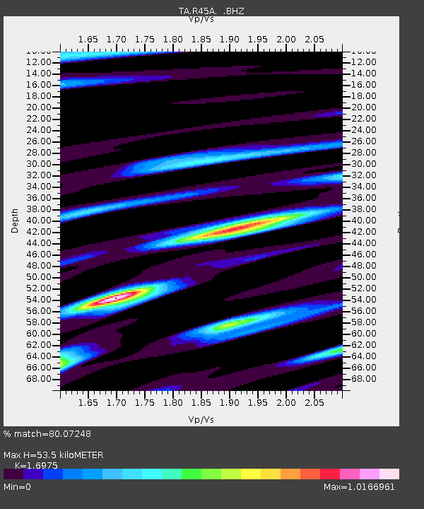
| Estimated Moho Depth: |
53.5 km |
| Estimated Crust Vp/Vs: |
1.70 |
| Assumed Crust Vp: |
6.444 km/s |
| Estimated Crust Vs: |
3.796 km/s |
| Estimated Crust Poisson's Ratio: |
0.23 |
|
| Radial Match: |
80.07248 % |
| Radial Bump: |
400 |
| Transverse Match: |
50.71187 % |
| Transverse Bump: |
400 |
| SOD ConfigId: |
512894 |
| Insert Time: |
2013-09-13 15:01:58.170 +0000 |
| GWidth: |
2.5 |
| Max Bumps: |
400 |
| Tol: |
0.001 |
|
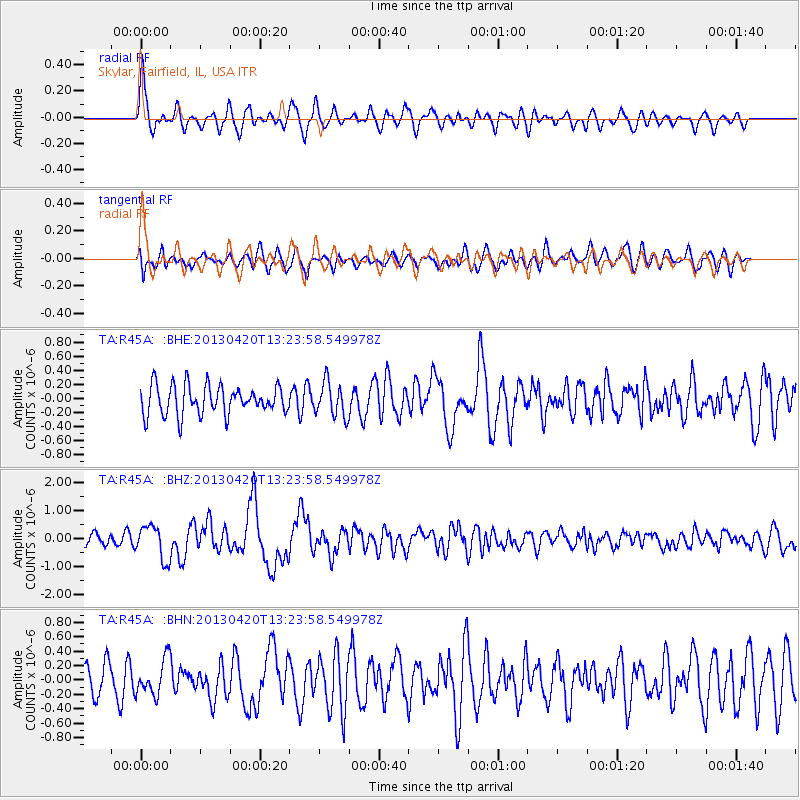
Signal To Noise
| Channel | StoN | STA | LTA |
| TA:R45A: :BHZ:20130420T13:23:58.549978Z | 3.7682257 | 5.998909E-7 | 1.5919717E-7 |
| TA:R45A: :BHN:20130420T13:23:58.549978Z | 1.0028082 | 2.4404238E-7 | 2.4335898E-7 |
| TA:R45A: :BHE:20130420T13:23:58.549978Z | 1.1775737 | 2.4116727E-7 | 2.0480014E-7 |
| Arrivals |
| Ps | 6.0 SECOND |
| PpPs | 22 SECOND |
| PsPs/PpSs | 28 SECOND |


