You are here: Home > Network List > TA - USArray Transportable Network (new EarthScope stations) Stations List
> Station T50A Nancy, KY, USA > Earthquake Result Viewer
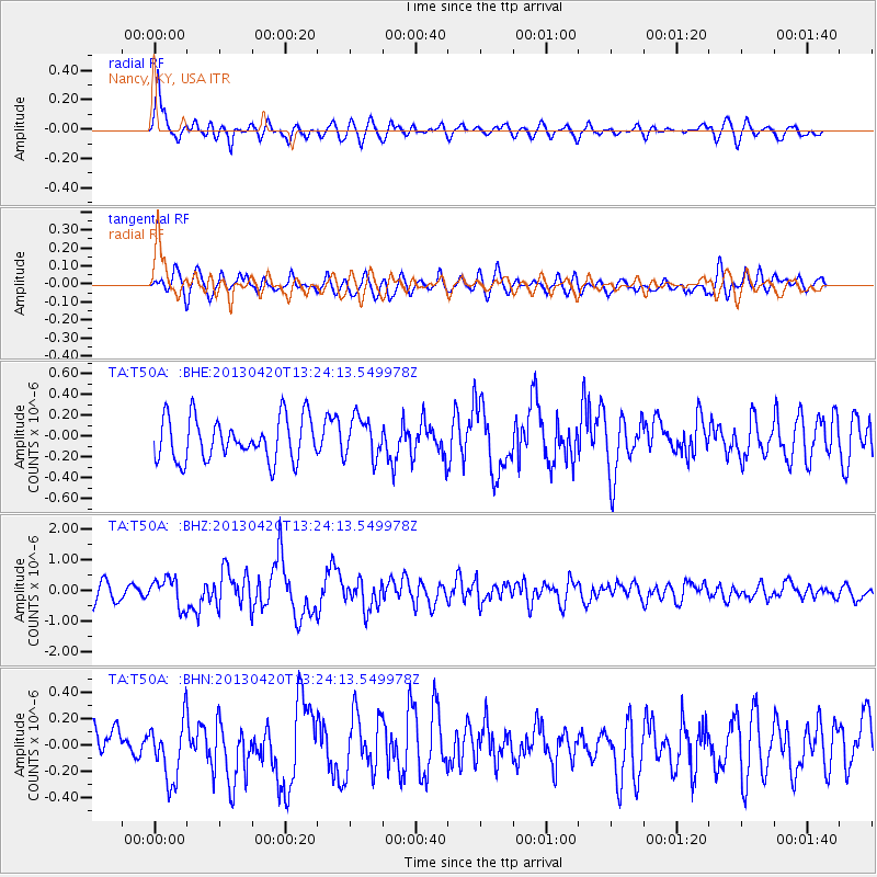
T50A Nancy, KY, USA - Earthquake Result Viewer
*The percent match for this event was below the threshold and hence no stack was calculated.
| Earthquake location: |
Kuril Islands |
| Earthquake latitude/longitude: |
50.1/157.1 |
| Earthquake time(UTC): |
2013/04/20 (110) 13:12:50 GMT |
| Earthquake Depth: |
18 km |
| Earthquake Magnitude: |
6.1 MW, 5.8 MB, 5.9 MS, 6.0 MW |
| Earthquake Catalog/Contributor: |
NEIC PDE/NEIC PDE-W |
|
| Network: |
TA USArray Transportable Network (new EarthScope stations) |
| Station: |
T50A Nancy, KY, USA |
| Lat/Lon: |
37.02 N/84.84 W |
| Elevation: |
302 m |
|
| Distance: |
77.5 deg |
| Az: |
46.366 deg |
| Baz: |
324.383 deg |
| Ray Param: |
$rayparam |
*The percent match for this event was below the threshold and hence was not used in the summary stack. |
|
| Radial Match: |
77.323555 % |
| Radial Bump: |
400 |
| Transverse Match: |
63.13877 % |
| Transverse Bump: |
400 |
| SOD ConfigId: |
512894 |
| Insert Time: |
2013-09-13 15:04:08.434 +0000 |
| GWidth: |
2.5 |
| Max Bumps: |
400 |
| Tol: |
0.001 |
|
Signal To Noise
| Channel | StoN | STA | LTA |
| TA:T50A: :BHZ:20130420T13:24:13.549978Z | 1.649837 | 4.6412592E-7 | 2.813162E-7 |
| TA:T50A: :BHN:20130420T13:24:13.549978Z | 1.7749547 | 2.3321897E-7 | 1.3139433E-7 |
| TA:T50A: :BHE:20130420T13:24:13.549978Z | 0.9471043 | 1.9230147E-7 | 2.030415E-7 |
| Arrivals |
| Ps | |
| PpPs | |
| PsPs/PpSs | |


