You are here: Home > Network List > US - United States National Seismic Network Stations List
> Station GLMI Grayling, Michigan, USA > Earthquake Result Viewer
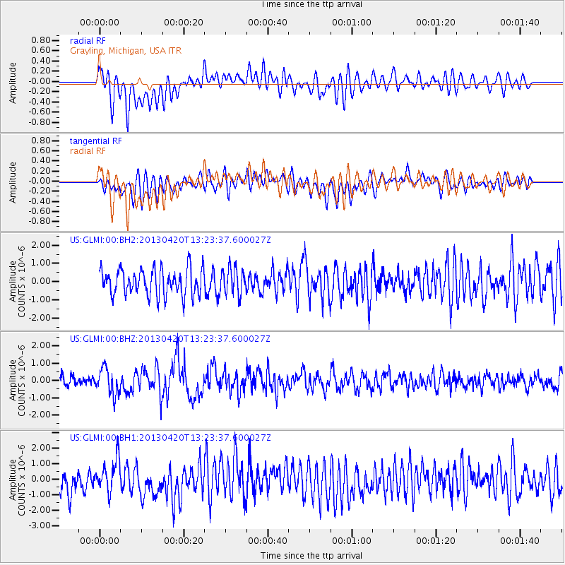
GLMI Grayling, Michigan, USA - Earthquake Result Viewer
*The percent match for this event was below the threshold and hence no stack was calculated.
| Earthquake location: |
Kuril Islands |
| Earthquake latitude/longitude: |
50.1/157.1 |
| Earthquake time(UTC): |
2013/04/20 (110) 13:12:50 GMT |
| Earthquake Depth: |
18 km |
| Earthquake Magnitude: |
6.1 MW, 5.8 MB, 5.9 MS, 6.0 MW |
| Earthquake Catalog/Contributor: |
NEIC PDE/NEIC PDE-W |
|
| Network: |
US United States National Seismic Network |
| Station: |
GLMI Grayling, Michigan, USA |
| Lat/Lon: |
44.82 N/84.62 W |
| Elevation: |
387 m |
|
| Distance: |
71.3 deg |
| Az: |
41.446 deg |
| Baz: |
323.201 deg |
| Ray Param: |
$rayparam |
*The percent match for this event was below the threshold and hence was not used in the summary stack. |
|
| Radial Match: |
61.48826 % |
| Radial Bump: |
400 |
| Transverse Match: |
51.808327 % |
| Transverse Bump: |
400 |
| SOD ConfigId: |
512894 |
| Insert Time: |
2013-09-13 15:10:46.944 +0000 |
| GWidth: |
2.5 |
| Max Bumps: |
400 |
| Tol: |
0.001 |
|
Signal To Noise
| Channel | StoN | STA | LTA |
| US:GLMI:00:BHZ:20130420T13:23:37.600027Z | 2.9977531 | 7.648914E-7 | 2.551549E-7 |
| US:GLMI:00:BH1:20130420T13:23:37.600027Z | 1.4567201 | 1.0533406E-6 | 7.230906E-7 |
| US:GLMI:00:BH2:20130420T13:23:37.600027Z | 0.96889126 | 6.976126E-7 | 7.200112E-7 |
| Arrivals |
| Ps | |
| PpPs | |
| PsPs/PpSs | |


