You are here: Home > Network List > UW - Pacific Northwest Regional Seismic Network Stations List
> Station MRBL Marblemount, WA, USA > Earthquake Result Viewer
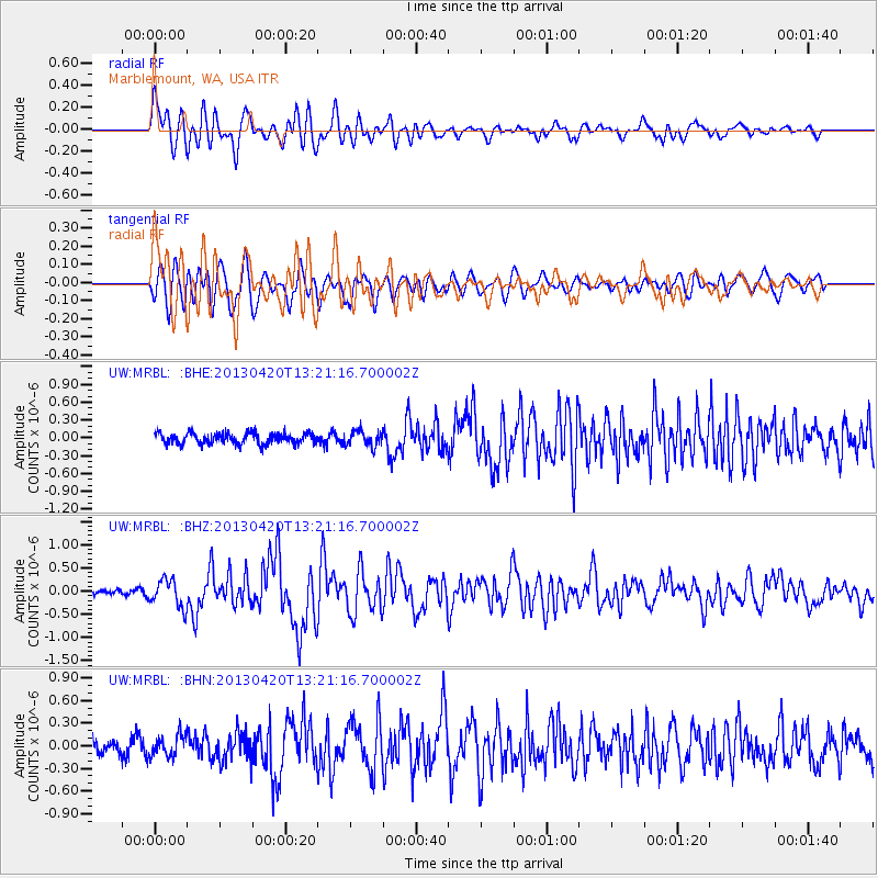
MRBL Marblemount, WA, USA - Earthquake Result Viewer
*The percent match for this event was below the threshold and hence no stack was calculated.
| Earthquake location: |
Kuril Islands |
| Earthquake latitude/longitude: |
50.1/157.1 |
| Earthquake time(UTC): |
2013/04/20 (110) 13:12:50 GMT |
| Earthquake Depth: |
18 km |
| Earthquake Magnitude: |
6.1 MW, 5.8 MB, 5.9 MS, 6.0 MW |
| Earthquake Catalog/Contributor: |
NEIC PDE/NEIC PDE-W |
|
| Network: |
UW Pacific Northwest Regional Seismic Network |
| Station: |
MRBL Marblemount, WA, USA |
| Lat/Lon: |
48.52 N/121.48 W |
| Elevation: |
75 m |
|
| Distance: |
50.5 deg |
| Az: |
58.382 deg |
| Baz: |
304.43 deg |
| Ray Param: |
$rayparam |
*The percent match for this event was below the threshold and hence was not used in the summary stack. |
|
| Radial Match: |
74.42201 % |
| Radial Bump: |
400 |
| Transverse Match: |
69.23529 % |
| Transverse Bump: |
400 |
| SOD ConfigId: |
512894 |
| Insert Time: |
2013-09-13 15:14:06.203 +0000 |
| GWidth: |
2.5 |
| Max Bumps: |
400 |
| Tol: |
0.001 |
|
Signal To Noise
| Channel | StoN | STA | LTA |
| UW:MRBL: :BHZ:20130420T13:21:16.700002Z | 3.8366044 | 2.9892996E-7 | 7.791524E-8 |
| UW:MRBL: :BHN:20130420T13:21:16.700002Z | 1.0412242 | 1.3797556E-7 | 1.3251281E-7 |
| UW:MRBL: :BHE:20130420T13:21:16.700002Z | 1.4015253 | 1.2855331E-7 | 9.172386E-8 |
| Arrivals |
| Ps | |
| PpPs | |
| PsPs/PpSs | |


