You are here: Home > Network List > BK - Berkeley Digital Seismograph Network Stations List
> Station HUMO Hull Mountain, OR > Earthquake Result Viewer
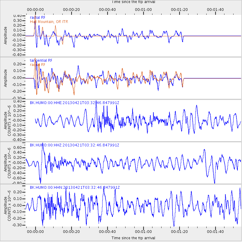
HUMO Hull Mountain, OR - Earthquake Result Viewer
*The percent match for this event was below the threshold and hence no stack was calculated.
| Earthquake location: |
Southeast Of Honshu, Japan |
| Earthquake latitude/longitude: |
29.9/138.9 |
| Earthquake time(UTC): |
2013/04/21 (111) 03:22:16 GMT |
| Earthquake Depth: |
422 km |
| Earthquake Magnitude: |
6.1 MW, 5.7 MB, 6.1 MW |
| Earthquake Catalog/Contributor: |
NEIC PDE/NEIC PDE-W |
|
| Network: |
BK Berkeley Digital Seismograph Network |
| Station: |
HUMO Hull Mountain, OR |
| Lat/Lon: |
42.61 N/122.96 W |
| Elevation: |
555 m |
|
| Distance: |
75.9 deg |
| Az: |
48.901 deg |
| Baz: |
297.62 deg |
| Ray Param: |
$rayparam |
*The percent match for this event was below the threshold and hence was not used in the summary stack. |
|
| Radial Match: |
48.119625 % |
| Radial Bump: |
400 |
| Transverse Match: |
59.540356 % |
| Transverse Bump: |
400 |
| SOD ConfigId: |
512894 |
| Insert Time: |
2013-09-13 15:26:17.626 +0000 |
| GWidth: |
2.5 |
| Max Bumps: |
400 |
| Tol: |
0.001 |
|
Signal To Noise
| Channel | StoN | STA | LTA |
| BK:HUMO:00:HHZ:20130421T03:32:46.847991Z | 5.8222904 | 3.9087269E-7 | 6.713383E-8 |
| BK:HUMO:00:HHN:20130421T03:32:46.847991Z | 1.5370264 | 1.2634457E-7 | 8.220066E-8 |
| BK:HUMO:00:HHE:20130421T03:32:46.847991Z | 2.36576 | 1.6883807E-7 | 7.136737E-8 |
| Arrivals |
| Ps | |
| PpPs | |
| PsPs/PpSs | |


