You are here: Home > Network List > PS - Pacific21 Stations List
> Station PATS 6onpei, Micronesia > Earthquake Result Viewer
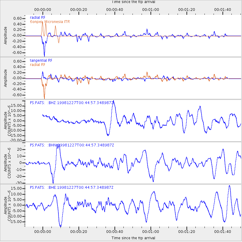
PATS 6onpei, Micronesia - Earthquake Result Viewer
*The percent match for this event was below the threshold and hence no stack was calculated.
| Earthquake location: |
Fiji Islands Region |
| Earthquake latitude/longitude: |
-21.6/-176.4 |
| Earthquake time(UTC): |
1998/12/27 (361) 00:38:26 GMT |
| Earthquake Depth: |
144 km |
| Earthquake Magnitude: |
6.1 MB, 6.9 UNKNOWN, 6.6 ME |
| Earthquake Catalog/Contributor: |
WHDF/NEIC |
|
| Network: |
PS Pacific21 |
| Station: |
PATS 6onpei, Micronesia |
| Lat/Lon: |
6.84 N/158.32 E |
| Elevation: |
10 m |
|
| Distance: |
37.6 deg |
| Az: |
315.964 deg |
| Baz: |
139.36 deg |
| Ray Param: |
$rayparam |
*The percent match for this event was below the threshold and hence was not used in the summary stack. |
|
| Radial Match: |
92.036995 % |
| Radial Bump: |
275 |
| Transverse Match: |
64.567726 % |
| Transverse Bump: |
400 |
| SOD ConfigId: |
4480 |
| Insert Time: |
2010-02-27 03:15:35.147 +0000 |
| GWidth: |
2.5 |
| Max Bumps: |
400 |
| Tol: |
0.001 |
|
Signal To Noise
| Channel | StoN | STA | LTA |
| PS:PATS: :BHN:19981227T00:44:57.348987Z | 3.4613428 | 4.437798E-6 | 1.2821031E-6 |
| PS:PATS: :BHE:19981227T00:44:57.348987Z | 1.7111807 | 1.9588663E-6 | 1.1447454E-6 |
| PS:PATS: :BHZ:19981227T00:44:57.348987Z | 0.9216369 | 2.1514118E-6 | 2.3343378E-6 |
| Arrivals |
| Ps | |
| PpPs | |
| PsPs/PpSs | |


