You are here: Home > Network List > IU - Global Seismograph Network (GSN - IRIS/USGS) Stations List
> Station FURI Mt. Furi, Ethiopia > Earthquake Result Viewer
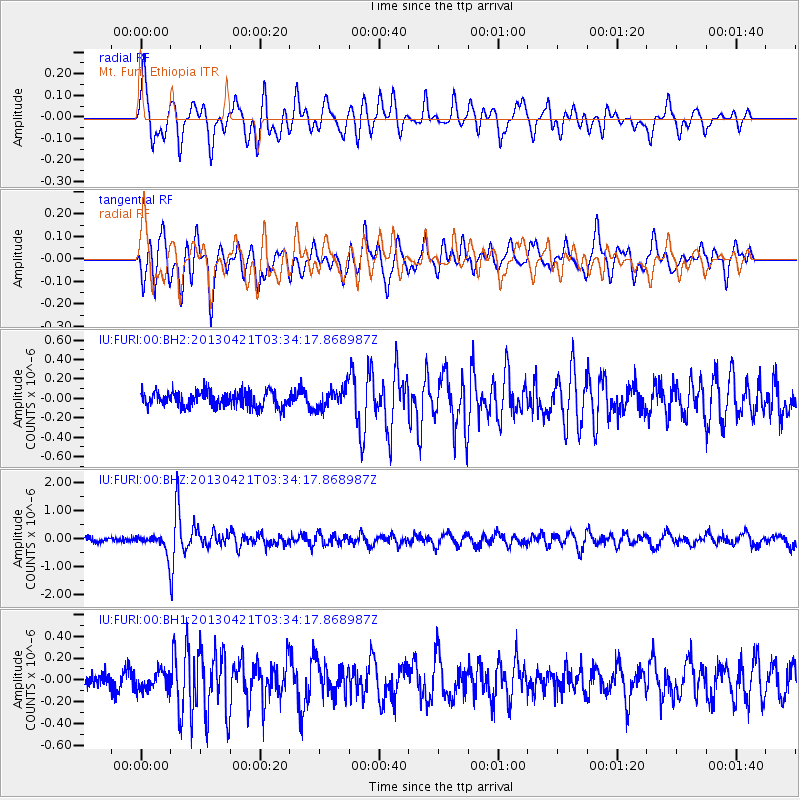
FURI Mt. Furi, Ethiopia - Earthquake Result Viewer
*The percent match for this event was below the threshold and hence no stack was calculated.
| Earthquake location: |
Southeast Of Honshu, Japan |
| Earthquake latitude/longitude: |
29.9/138.9 |
| Earthquake time(UTC): |
2013/04/21 (111) 03:22:16 GMT |
| Earthquake Depth: |
422 km |
| Earthquake Magnitude: |
6.1 MW, 5.7 MB, 6.1 MW |
| Earthquake Catalog/Contributor: |
NEIC PDE/NEIC PDE-W |
|
| Network: |
IU Global Seismograph Network (GSN - IRIS/USGS) |
| Station: |
FURI Mt. Furi, Ethiopia |
| Lat/Lon: |
8.90 N/38.68 E |
| Elevation: |
2570 m |
|
| Distance: |
94.3 deg |
| Az: |
282.763 deg |
| Baz: |
58.956 deg |
| Ray Param: |
$rayparam |
*The percent match for this event was below the threshold and hence was not used in the summary stack. |
|
| Radial Match: |
72.707146 % |
| Radial Bump: |
400 |
| Transverse Match: |
74.15325 % |
| Transverse Bump: |
400 |
| SOD ConfigId: |
512894 |
| Insert Time: |
2013-09-13 15:35:48.316 +0000 |
| GWidth: |
2.5 |
| Max Bumps: |
400 |
| Tol: |
0.001 |
|
Signal To Noise
| Channel | StoN | STA | LTA |
| IU:FURI:00:BHZ:20130421T03:34:17.868987Z | 3.6205938 | 3.2667603E-7 | 9.0227196E-8 |
| IU:FURI:00:BH1:20130421T03:34:17.868987Z | 0.7545843 | 8.6304794E-8 | 1.14373954E-7 |
| IU:FURI:00:BH2:20130421T03:34:17.868987Z | 1.3325887 | 1.0599413E-7 | 7.954002E-8 |
| Arrivals |
| Ps | |
| PpPs | |
| PsPs/PpSs | |


