You are here: Home > Network List > PF - Volcanologic Network of Piton de Fournaise-OVPF Stations List
> Station GPS Grandes Pentes Sud > Earthquake Result Viewer
GPS Grandes Pentes Sud - Earthquake Result Viewer
*The percent match for this event was below the threshold and hence no stack was calculated.
| Earthquake location: |
East Of South Sandwich Islands |
| Earthquake latitude/longitude: |
-60.0/-18.7 |
| Earthquake time(UTC): |
2014/07/26 (207) 11:13:48 GMT |
| Earthquake Depth: |
10 km |
| Earthquake Magnitude: |
5.8 MWC, 5.8 MWC |
| Earthquake Catalog/Contributor: |
NEIC PDE/NEIC COMCAT |
|
| Network: |
PF Volcanologic Network of Piton de Fournaise-OVPF |
| Station: |
GPS Grandes Pentes Sud |
| Lat/Lon: |
21.27 S/55.76 E |
| Elevation: |
1004 m |
|
| Distance: |
64.1 deg |
| Az: |
87.741 deg |
| Baz: |
212.53 deg |
| Ray Param: |
$rayparam |
*The percent match for this event was below the threshold and hence was not used in the summary stack. |
|
| Radial Match: |
70.07949 % |
| Radial Bump: |
400 |
| Transverse Match: |
63.845192 % |
| Transverse Bump: |
366 |
| SOD ConfigId: |
3390531 |
| Insert Time: |
2019-04-13 01:17:35.773 +0000 |
| GWidth: |
2.5 |
| Max Bumps: |
400 |
| Tol: |
0.001 |
|
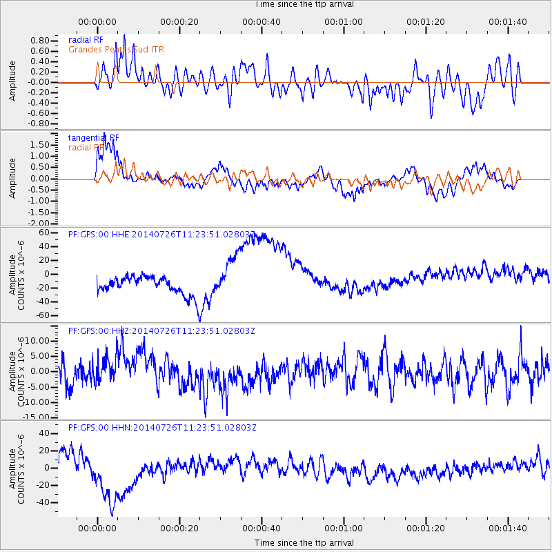
Signal To Noise
| Channel | StoN | STA | LTA |
| PF:GPS:00:HHZ:20140726T11:23:51.02803Z | 0.9445673 | 3.9660426E-6 | 4.1987932E-6 |
| PF:GPS:00:HHN:20140726T11:23:51.02803Z | 5.1143107 | 3.914421E-5 | 7.653859E-6 |
| PF:GPS:00:HHE:20140726T11:23:51.02803Z | 2.5253308 | 3.1867603E-5 | 1.261918E-5 |
| Arrivals |
| Ps | |
| PpPs | |
| PsPs/PpSs | |


